
IMAGES TAKEN NEAR TO
Dechmont Road, EDINBURGH, EH12 8JD
Introduction
This page details the photographs taken nearby to Dechmont Road, EH12 8JD by members of the Geograph project.
The Geograph project started in 2005 with the aim of publishing, organising and preserving representative images for every square kilometre of Great Britain, Ireland and the Isle of Man.

There are currently over 7.5m images from over14,400 individuals and you can help contribute to the project by visiting https://www.geograph.org.uk
Image Map
Images are licensed for reuse under creativecommons.org/licenses/by-sa/2.0
Notes
- Clicking on the map will re-center to the selected point.
- The higher the marker number, the further away the image location is from the centre of the postcode.
Image Listing (27 Images Found)
Images are licensed for reuse under creativecommons.org/licenses/by-sa/2.0
Image
Details
Distance
1

A pair of old stone cottages on the Glasgow Road
Changed days, and traffic, from when they were first built.
Image: © M J Richardson
Taken: 19 Sep 2008
0.08 miles
2

Automak on Glasgow Road
Service and MOT centre http://www.automak.co.uk/ .
Image: © Thomas Nugent
Taken: 19 May 2013
0.09 miles
3

Glasgow Road
Looking towards the city, near Gyle Park gardens.
Image: © Thomas Nugent
Taken: 19 May 2013
0.09 miles
4

Glasgow Road, Maybury
Looking east from the bus stop at the Marriott Hotel.
Image: © Thomas Nugent
Taken: 23 Oct 2011
0.11 miles
5

Signs on Glasgow Road
The matrix sign warns of fog ahead. Looking west at the junction of Gyle Park Gardens.
Image: © Thomas Nugent
Taken: 20 May 2013
0.11 miles

7

Gyle Park Gardens
Off Edinburgh Road.
Image: © Thomas Nugent
Taken: 19 May 2013
0.12 miles
8
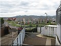
The view from East Craigs - 2008
Compare this picture with one taken in the late 1960s Image Housing has replaced a school, which replaced an open landscape clear right across to the Pentland Hills. The school was demolished and rebuilt in 2003 a few hundred metres down the road. The building from which the earlier photo was taken [the original building of what was the 'Seed Testing Station'], and others on the site, have all been demolished and redeveloped as housing. This photo was taken from one of the site buildings just a few metres away from where the original was taken.
Image: © M J Richardson
Taken: 7 Jul 2008
0.13 miles
9
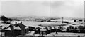
The view from East Craigs - late 1960s
A winter scene looking south to the Pentland Hills. Craigmount High School was built on the site in 1970/71. It has since been demolished and replaced by housing, so the view now is completely different Image I do not have the exact date of the photo, but certainly between 1965 and 1969.
Image: © M J Richardson
Taken: Unknown
0.13 miles
10

Gyle Park Gardens
New housing just off the A8 Glasgow Road in Corstorphine.
Image: © M J Richardson
Taken: 19 Sep 2008
0.13 miles