IMAGES TAKEN NEAR TO
Queen Victoria Street, LONDON, EC4V 4LA
Introduction
This page details the photographs taken nearby to Queen Victoria Street, EC4V 4LA by members of the Geograph project.
The Geograph project started in 2005 with the aim of publishing, organising and preserving representative images for every square kilometre of Great Britain, Ireland and the Isle of Man.

There are currently over 7.5m images from over14,400 individuals and you can help contribute to the project by visiting https://www.geograph.org.uk
Image Map
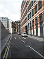
Images are licensed for reuse under creativecommons.org/licenses/by-sa/2.0
Notes
- Clicking on the map will re-center to the selected point.
- The higher the marker number, the further away the image location is from the centre of the postcode.
Image Listing (3323 Images Found)
Images are licensed for reuse under creativecommons.org/licenses/by-sa/2.0
Image
Details
Distance
2
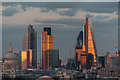
London Skyline from New Zealand House
St Paul's Cathedral, Tower 42, The Gherkin and the Cheese Grater can be seen.
Image: © Christine Matthews
Taken: 8 Sep 2016
0.01 miles
3
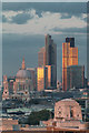
London Skyline from New Zealand House
St Paul's Cathedral and Tower 42 can be seen.
Image: © Christine Matthews
Taken: 8 Sep 2016
0.01 miles
6
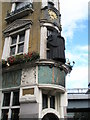
Laughing friar above City Pub
By Blackfriars Tube Station.
Image: © Basher Eyre
Taken: 13 Aug 2008
0.02 miles
7
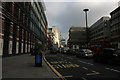
Junction of Blackfriars Lane and Queen Victoria Street
Image: © Basher Eyre
Taken: 13 Aug 2008
0.02 miles
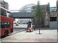
8
Railway Bridge emerging from Blackfriars Station
Image: © N Chadwick
Taken: 24 Oct 2010
0.02 miles

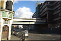
10
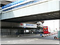
Blackfriars Railway Station
Currently closed for re-building.
Image: © Peter Trimming
Taken: 4 May 2009
0.02 miles