IMAGES TAKEN NEAR TO
Queen Victoria Street, LONDON, EC4V 4AY
Introduction
This page details the photographs taken nearby to Queen Victoria Street, EC4V 4AY by members of the Geograph project.
The Geograph project started in 2005 with the aim of publishing, organising and preserving representative images for every square kilometre of Great Britain, Ireland and the Isle of Man.

There are currently over 7.5m images from over14,400 individuals and you can help contribute to the project by visiting https://www.geograph.org.uk
Image Map
Images are licensed for reuse under creativecommons.org/licenses/by-sa/2.0
Notes
- Clicking on the map will re-center to the selected point.
- The higher the marker number, the further away the image location is from the centre of the postcode.
Image Listing (3901 Images Found)
Images are licensed for reuse under creativecommons.org/licenses/by-sa/2.0
Image
Details
Distance
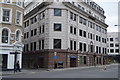
1
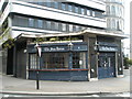
The Sea Horse
Located at 64 Queen Victoria Street
Image: © Basher Eyre
Taken: 13 Apr 2008
0.01 miles
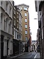
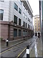
2
Junction of Queen Victoria Street and Huggin Hill
Image: © Basher Eyre
Taken: 13 Apr 2008
0.01 miles
3
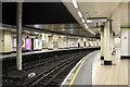
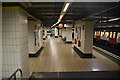
Mansion House Station
Served by the District and Circle lines. The station was opened by the Metropolitan District Railway in 1871 and acted as the terminus of the route from west London until the line was extended eastwards in 1884. Mansion House retains three platforms from its days as the terminus of the line - although trains are sometimes still terminated here, currently Tower Hill is more normally used as a terminus.
Map locations given are approximate due to the difficulty in accurately locating an underground structure.
Image: © Martin Addison
Taken: 15 May 2015
0.01 miles
5
The Square Mile in one day (winter 6)
Great Trinity Lane which is named after a long gone priory Holy Trinity the Great
Image: © Basher Eyre
Taken: 20 Nov 2016
0.02 miles
8
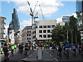
Freecycle riders on Queen Victoria Street
Cyclists enjoying the annual traffic-free ride round the City.
Image: © Stephen Craven
Taken: 9 Aug 2014
0.02 miles
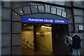
9
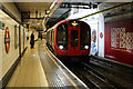
Mansion House Station
Served by the District and Circle lines. The station was opened by the Metropolitan District Railway in 1871 and acted as the terminus of the route from west London until the line was extended eastwards in 1884. Mansion House retains three platforms from its days as the terminus of the line - although trains are sometimes still terminated here, currently Tower Hill is more normally used as a terminus. Here, a westbound Circle Line service formed of S7 stock arrives passing through a tiny shaft of daylight in this otherwise enclosed station.
Map locations given are approximate due to the difficulty in accurately locating an underground structure.
Image: © Martin Addison
Taken: 15 May 2015
0.02 miles