IMAGES TAKEN NEAR TO
Queenhithe, LONDON, EC4V 3DQ
Introduction
This page details the photographs taken nearby to Queenhithe, EC4V 3DQ by members of the Geograph project.
The Geograph project started in 2005 with the aim of publishing, organising and preserving representative images for every square kilometre of Great Britain, Ireland and the Isle of Man.

There are currently over 7.5m images from over14,400 individuals and you can help contribute to the project by visiting https://www.geograph.org.uk
Image Map
Images are licensed for reuse under creativecommons.org/licenses/by-sa/2.0
Notes
- Clicking on the map will re-center to the selected point.
- The higher the marker number, the further away the image location is from the centre of the postcode.
Image Listing (3608 Images Found)
Images are licensed for reuse under creativecommons.org/licenses/by-sa/2.0
Image
Details
Distance
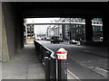
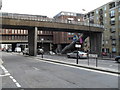
1

Footbridge over Upper Thames Street
Looks rather silly among the solid office blocks.
Image: © Jonathan Thacker
Taken: 17 Mar 2012
0.01 miles

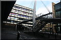
4
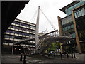
Modern footbridge on Upper Thames Street
See Image for a different view of the bridge.
Image: © Stephen Craven
Taken: 21 Aug 2014
0.02 miles
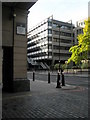
6
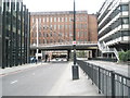
Looking westwards along Upper Thames Street
Image: © Basher Eyre
Taken: 12 Jul 2008
0.02 miles

9
Corner of Kennet Wharf Lane where it joins Upper Thames Street
Image: © Basher Eyre
Taken: 14 Sep 2008
0.02 miles
10
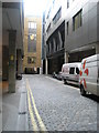
Looking southwards down Kennett Wharf Lane
Image: © Basher Eyre
Taken: 14 Sep 2008
0.02 miles