IMAGES TAKEN NEAR TO
Bloomberg Arcade, LONDON, EC4N 8AR
Introduction
This page details the photographs taken nearby to Bloomberg Arcade, EC4N 8AR by members of the Geograph project.
The Geograph project started in 2005 with the aim of publishing, organising and preserving representative images for every square kilometre of Great Britain, Ireland and the Isle of Man.

There are currently over 7.5m images from over14,400 individuals and you can help contribute to the project by visiting https://www.geograph.org.uk
Image Map
Images are licensed for reuse under creativecommons.org/licenses/by-sa/2.0
Notes
- Clicking on the map will re-center to the selected point.
- The higher the marker number, the further away the image location is from the centre of the postcode.
Image Listing (3370 Images Found)
Images are licensed for reuse under creativecommons.org/licenses/by-sa/2.0
Image
Details
Distance
2
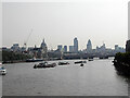
View from Waterloo Bridge along the River Thames to the City of London
On the skyline the three most prominent buildings are, from left to right, St Paul's Cathedral, Tower 42, aka the NatWest Tower, and the Gherkin, formerly 30 St Mary Axe. NatWest no longer occupy Tower 42.
The ship with the buff funnel, below St Paul's, is HMS President which served in her final naval role as HQ of the London Royal Naval Reserve. She is now in Chatham awaiting restoration. Her history can be found at [https://en.wikipedia.org/wiki/HMS_President_(1918)]
Image: © Rod Grealish
Taken: 6 Jun 2006
0.01 miles
4
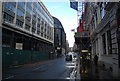
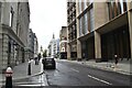
Bus negotiating a traffic light free Cannon Street
Image: © Basher Eyre
Taken: 12 Jul 2008
0.01 miles
6
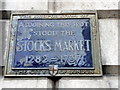
Stocks Market Blue Plaque, Mansion House, London EC4
Between 1282 and 1737 The Stocks Market stood at this spot.
Image: © Christine Matthews
Taken: 1 Apr 2011
0.02 miles
7
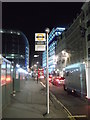
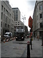
Cannon Street Coach Stop, London
Looking along the road heading towards Cannon Street Station (the bright blue building in the background).
On the left, the curved modern building is the Walbrook Building.
See Image
Image: © David Anstiss
Taken: 18 Dec 2011
0.02 miles
8
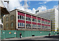
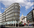
Temple Court, Cannon Street
Part of it least. Untouched at the time of the photo, but it doesn't seem plausible that it will survive much longer when the remainder of the 1950s/1960s Bucklersbury House and Temple Court development surrounding it (Image]) was being demolished. Designed by O. Campbell-Jones & Ronald Fielding in 1962 for Legal and General Assurance.
Image: © Stephen Richards
Taken: 14 May 2011
0.02 miles
10
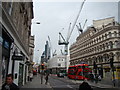
View of the Gherkin, Cheese Grater and a plethora of cranes from Queen Victoria Street
Looking north-northeast. Some office blocks have been demolished on the right hand side of the road, presumably for Crossrail works or perhaps work being done on Cannon Street station.
Image: © Robert Lamb
Taken: 12 Apr 2014
0.02 miles