IMAGES TAKEN NEAR TO
Whittington Avenue, LONDON, EC3V 1LE
Introduction
This page details the photographs taken nearby to Whittington Avenue, EC3V 1LE by members of the Geograph project.
The Geograph project started in 2005 with the aim of publishing, organising and preserving representative images for every square kilometre of Great Britain, Ireland and the Isle of Man.

There are currently over 7.5m images from over14,400 individuals and you can help contribute to the project by visiting https://www.geograph.org.uk
Image Map (Loading...)


Getting Data...Please wait
Leaflet Map data © OpenStreetMap
Images are licensed for reuse under creativecommons.org/licenses/by-sa/2.0
Notes
- Clicking on the map will re-center to the selected point.
- The higher the marker number, the further away the image location is from the centre of the postcode.
Image Listing (4562 Images Found)
Images are licensed for reuse under creativecommons.org/licenses/by-sa/2.0
Image
Details
Distance
1

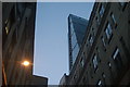
City of London skyline, January 2014
There are some noticeable changes since my view from the London Eye, Image In the centre the "Cheesegrater", 122 Leadenhall Street has grown to loom over the "Gherkin" (it is 45m taller). On the right the concrete core of 20 Fenchurch Street has now acquired the rest of the building dubbed the "Walkie-Talkie".
This view was taken from the Terrace at Somerset House.
Image: © Keith Edkins
Taken: 22 Jan 2014
0.00 miles

3
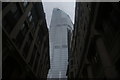
View of the Cheese Grater from Whittington Avenue
Looking north-northeast.
Image: © Robert Lamb
Taken: 5 Mar 2016
0.01 miles
4

The view to the north from the Sky Garden at 20 Fenchurch Street
On the left is Tower 42, originally known as the Natwest Tower when first built and the tallest building in the UK at the time at 600ft. It is now the third tallest skyscraper in the City of London. In the centre is the 737ft high 122 Leadenhall Street, known colloquially as 'The Cheesegrater' because of its appearance. On the right is 30 St Mary Axe, known as 'The Gherkin', which is 591ft high.
Image: © Rod Allday
Taken: 30 Nov 2015
0.01 miles
5
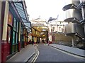
City of London, Leadenhall Market entrance
Leadenhall Place, with stalls (now shops) looking resplendent in burgundy, green and cream: http://www.cityoflondon.gov.uk/things-to-do/visiting-the-city/food-drink-and-shopping/leadenhall-market/Pages/Leadenhall-Market-history.aspx
Image: © Mike Faherty
Taken: 16 Feb 2014
0.01 miles
7
View of 22 Bishopsgate from Whittington Avenue
Looking northeast.
Image: © Robert Lamb
Taken: 3 Nov 2019
0.01 miles
8
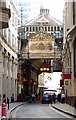
Leadenhall Market From Leadenhall Street
A busy market, hosting a May Day event.
http://www.leadenhallmarket.co.uk/index.php
Image: © Peter Trimming
Taken: 1 May 2009
0.01 miles
9

Former entrance to Lloyd's of London on Leadenhall Street
Designed by Edwin Cooper in 1925 for an earlier Lloyd's building, it features quite a lot as a backdrop on BBC News live broadcasts.
Image: © Robert Lamb
Taken: 7 Feb 2010
0.01 miles
10
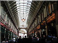
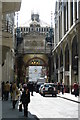
Leadenhall Market on Whittington Avenue
Leadenhall Market is a covered market in London, located on Gracechurch Street but with vehicular access also available via Whittington Avenue to the north and Lime Street to the south and east, and additional pedestrian access via a number of narrow passageways. It is one of the oldest markets in London, dating back to the 14th century, and is located in the historic centre of the City of London.
Image: © Steve Daniels
Taken: 6 Sep 2013
0.01 miles