IMAGES TAKEN NEAR TO
Philpot Lane, LONDON, EC3M 8AA
Introduction
This page details the photographs taken nearby to Philpot Lane, EC3M 8AA by members of the Geograph project.
The Geograph project started in 2005 with the aim of publishing, organising and preserving representative images for every square kilometre of Great Britain, Ireland and the Isle of Man.

There are currently over 7.5m images from over14,400 individuals and you can help contribute to the project by visiting https://www.geograph.org.uk
Image Map (Loading...)


Getting Data...Please wait
Leaflet Map data © OpenStreetMap
Images are licensed for reuse under creativecommons.org/licenses/by-sa/2.0
Notes
- Clicking on the map will re-center to the selected point.
- The higher the marker number, the further away the image location is from the centre of the postcode.
Image Listing (4220 Images Found)
Images are licensed for reuse under creativecommons.org/licenses/by-sa/2.0
Image
Details
Distance
1
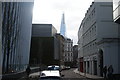
View of the Shard from Philpot Lane
Looking south-southwest.
Image: © Robert Lamb
Taken: 1 Feb 2015
0.00 miles
2
View of the Shard from Philpot Lane #2
Looking south-southwest.
Image: © Robert Lamb
Taken: 8 Jun 2014
0.00 miles
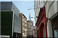
3
View down Philpot Lane from Fenchurch Street
Looking south-southwest.
Image: © Robert Lamb
Taken: 1 Feb 2015
0.00 miles
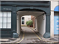
4
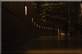
View along the pavement on Philpot Lane next to the wall by the Walkie Talkie
Looking south-southwest.
Image: © Robert Lamb
Taken: 5 Mar 2016
0.00 miles
5

View of Centre Point from the Tower Bridge Exhibition
Looking north-northwest.
Image: © Robert Lamb
Taken: 1 Feb 2014
0.01 miles
6

Old Boundary Marker by Philpot Lane, City of London
Parish Boundary Marker by the UC road, in parish of City of London (City of London District), Philpot Lane EC3, above No. 9, high on wall just above coffee shop entrance. On plain wall of refurbished building, no longer on bricks. To the left of: CL_SDB01pb Image
Inscription reads:-
Sᵀ.
A.H
1888
Surveyed
Milestone Society National ID: CL_SAH01pb
Image: © Milestone Society
Taken: Unknown
0.01 miles
7
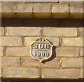
Old Boundary Marker by Philpot Lane, City of London
Parish Boundary Marker by the UC road, in parish of City of London (City of London District), Philpot Lane EC3, above No. 9. On plain wall of refurbished building, no longer on bricks. To the right of: CL_SAH01pb Image
Inscription reads:-
70
S.D.P.
1888
Surveyed
Milestone Society National ID: CL_SDB01pb
Image: © Milestone Society
Taken: Unknown
0.01 miles
8
View up Gracechurch Street
Looking north-northeast.
Image: © Robert Lamb
Taken: 1 Feb 2015
0.01 miles
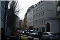
9
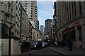
Brabant Court, City of London
Many of the streets of the City of London are deserted during the Covid-19 lockdown.
Image: © Roger Jones
Taken: 29 Apr 2020
0.01 miles
10
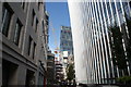
View of the Cheese Grater and the Walkie Talkie from Philpot Lane
Looking north-northeast.
Image: © Robert Lamb
Taken: 28 Aug 2016
0.01 miles