IMAGES TAKEN NEAR TO
Eastcheap, LONDON, EC3M 1LH
Introduction
This page details the photographs taken nearby to Eastcheap, EC3M 1LH by members of the Geograph project.
The Geograph project started in 2005 with the aim of publishing, organising and preserving representative images for every square kilometre of Great Britain, Ireland and the Isle of Man.

There are currently over 7.5m images from over14,400 individuals and you can help contribute to the project by visiting https://www.geograph.org.uk
Image Map (Loading...)


Getting Data...Please wait
Leaflet Map data © OpenStreetMap
Images are licensed for reuse under creativecommons.org/licenses/by-sa/2.0
Notes
- Clicking on the map will re-center to the selected point.
- The higher the marker number, the further away the image location is from the centre of the postcode.
Image Listing (4054 Images Found)
Images are licensed for reuse under creativecommons.org/licenses/by-sa/2.0
Image
Details
Distance
1
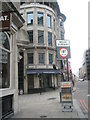
Presumably referring to the road infrastructure - not the sandwiches
Taken in Eastcheap.
Image: © Basher Eyre
Taken: 13 Feb 2010
0.00 miles
2
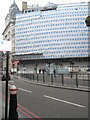
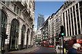
That's one big sheet!
Taken in Cheapside looking towards Gracechurch Street.
Image: © Basher Eyre
Taken: 13 Feb 2010
0.01 miles
3
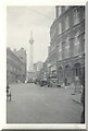
Fire Monument from the (then) Fish Market
Taken on a Brownie box camera when I was 13
Image: © Elliott Simpson
Taken: Unknown
0.01 miles
4
A-spiring to find a hundred churches (103)
I am standing just in front of St Leonard Eastcheap https://en.wikipedia.org/wiki/St_Leonard,_Eastcheap which after the Great Fire was not rebuilt and the parish united with St Benet Gracechurch, whose parish boundary is about where Starbucks is
Image: © Basher Eyre
Taken: 20 Nov 2016
0.01 miles
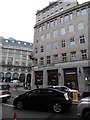
5
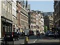
Eastcheap, City of London
Eastcheap is one of the City's principal west-east thoroughfares, leading from the bottom of Gracechurch Street towards the Tower of London.
Image: © Stephen McKay
Taken: 21 Apr 2011
0.01 miles
6
Open top bus on King William Street
Image: © Oast House Archive
Taken: 1 May 2009
0.01 miles
7
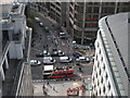
Looking down from the Monument
Looking straight down to street level from the 50m high balcony of the Monument, making sure not to drop the camera.
Image: © Stephen McKay
Taken: 13 Apr 2007
0.01 miles
8
View of the Cheese Grater from the Monument road junction
Looking south-southeast.
Image: © Robert Lamb
Taken: 28 Aug 2016
0.01 miles
9
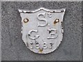
Old Boundary Marker by Pudding Lane, City of London
Parish Boundary Marker by the UC road, in parish of City Of London (City of London District), Pudding Lane EC3, on wall of No 2 Eastcheap (former bank) at pavement level, East side of road.
Inscription reads:-
Sᵗ.
G B
1881
Surveyed
Milestone Society National ID: CL_SGB01pb
Image: © Milestone Society
Taken: Unknown
0.01 miles
10
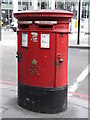
George VI postbox, Eastcheap / Fish Street Hill, EC3
The location of this postbox is shown in Image
Image: © Mike Quinn
Taken: 6 Apr 2011
0.01 miles