IMAGES TAKEN NEAR TO
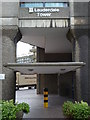
Lauderdale Place, Barbican, LONDON, EC2Y 8EN
Introduction
This page details the photographs taken nearby to Lauderdale Place, Barbican, EC2Y 8EN by members of the Geograph project.
The Geograph project started in 2005 with the aim of publishing, organising and preserving representative images for every square kilometre of Great Britain, Ireland and the Isle of Man.

There are currently over 7.5m images from over14,400 individuals and you can help contribute to the project by visiting https://www.geograph.org.uk
Image Map (Loading...)


Getting Data...Please wait
Leaflet Map data © OpenStreetMap
Images are licensed for reuse under creativecommons.org/licenses/by-sa/2.0
Notes
- Clicking on the map will re-center to the selected point.
- The higher the marker number, the further away the image location is from the centre of the postcode.
Image Listing (2028 Images Found)
Images are licensed for reuse under creativecommons.org/licenses/by-sa/2.0
Image
Details
Distance
1
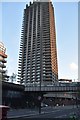
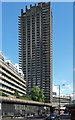
Barbican Centre, London EC1
One of the tower blocks of the Barbican development.
Image: © Christine Matthews
Taken: 15 May 2016
0.00 miles
2
The Barbican Estate EC2
Taken from Long Lane (EC1) at the junction with Aldersgate Street
Image: © Robin Sones
Taken: 24 Jul 2013
0.01 miles
3
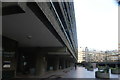
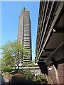
View along the underside of Lauderdale Tower from the Barbican Estate
Looking north-northeast.
Image: © Robert Lamb
Taken: 4 Feb 2017
0.01 miles
5
Barbican tower
One of three tall buildings, part of the Barbican Estate.
Image: © Hamish Griffin
Taken: 7 May 2018
0.01 miles
7
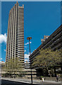
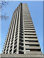
Barbican, Silk Street (5)
This is Lauderdale Tower, the distinctive balconies evident on the left. When built the residential towers were Europe's highest. Grade II listed.
"There is nothing quite like the Barbican Estate in all British architecture", wrote Pevsner. This is attributed to its sheer scale, magnified by the use of concrete, and its segregation of traffic and pedestrians by means of elevated walkways. The estate was the second stage in the Corporation of London's plan to reverse its depopulation as a result of the war (it was built on land ravaged by bombing). The architects chosen were Chamberlin, Powell & Bon, fresh from the City's Golden Lane Estate, work commenced in 1963 and was not completed until 1981. A total of 2,100 flats were built over the 35-acre site, which also includes a school and arts centre. All in all it is an impressive scheme, but the sheer amount of concrete on display renders it less immediately likeable than, say, a Georgian terrace! Sun and blue sky certainly help. Its salubrity, however, gives the lie to the specious idea that large concrete housing estates are intrinsically crime-ridden. That might just have more to do with social issues than the choice of architectural style or building material. It is now listed, quite a feat for so much Brutalism.
Image: © Stephen Richards
Taken: 14 May 2011
0.01 miles
8
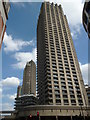
Lauderdale Tower, Beech Street (1)
The westernmost of the Barbican Estate's three 400-foot towers. Lauderdale was completed in 1974 to the designs of Chamberlain, Powell & Bon.
More info on the estate: Image
Image: © Stephen Richards
Taken: 2 Apr 2016
0.01 miles
9
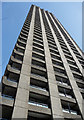
Lauderdale Tower, Beech Street (2)
The westernmost of the Barbican Estate's three 400-foot towers. Lauderdale was completed in 1974 to the designs of Chamberlain, Powell & Bon.
More info on the estate: Image
Image: © Stephen Richards
Taken: 2 Apr 2016
0.01 miles