IMAGES TAKEN NEAR TO
Silk Street, Barbican, LONDON, EC2Y 8DT
Introduction
This page details the photographs taken nearby to Silk Street, Barbican, EC2Y 8DT by members of the Geograph project.
The Geograph project started in 2005 with the aim of publishing, organising and preserving representative images for every square kilometre of Great Britain, Ireland and the Isle of Man.

There are currently over 7.5m images from over14,400 individuals and you can help contribute to the project by visiting https://www.geograph.org.uk
Image Map (Loading...)


Getting Data...Please wait
Leaflet Map data © OpenStreetMap
Images are licensed for reuse under creativecommons.org/licenses/by-sa/2.0
Notes
- Clicking on the map will re-center to the selected point.
- The higher the marker number, the further away the image location is from the centre of the postcode.
Image Listing (1579 Images Found)
Images are licensed for reuse under creativecommons.org/licenses/by-sa/2.0
Image
Details
Distance
2
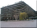
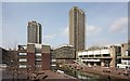
Not exactly a forest
The Barbican's ratio of trees to people or trees to bricks must be very small on anyone's scale.
Image: © Basher Eyre
Taken: 28 Dec 2007
0.01 miles
3
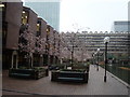
The private part of the Barbican Centre courtyard
The courtyard from this point onward is privately owned. The blossom is certainly blooming early - could spring really be in the air? It certainly provides a colourful contrast to the dull grey (but interesting) 1960s architecture around the Barbican Centre! Looking south-southeast.
Image: © Robert Lamb
Taken: 20 Feb 2011
0.01 miles
4
View of towerblock off London Wall, from the courtyard of the Barbican Centre
Looking south-southeast.
Image: © Robert Lamb
Taken: 20 Feb 2011
0.01 miles
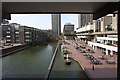
5
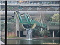
Artificial waterfall in the Barbican Centre courtyard
I had to zoom in on this as the courtyard from this point onwards is private property. Looking east-southeast.
Image: © Robert Lamb
Taken: 20 Feb 2011
0.01 miles
6
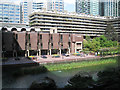
Guildhall School of Music and Drama, Barbican EC2
The brown brick building is the school, or part of it. This part of the pool is to the east of the Gilbert's Bridge walkway.
Image: © Robin Stott
Taken: 13 May 2012
0.02 miles
7
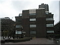
City of London Girl's School
My mother, being a very practical sort of person, asked where the girls would play. Perhaps a fellow Geograph Hunter might help.
Image: © Basher Eyre
Taken: 28 Dec 2007
0.02 miles
9
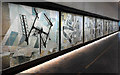
Murals, Barbican (1)
Nine murals by Dorothy Annan commissioned by the Ministry of Works in 1960 for the Fleet Building on Farringdon Street (Image]). To tie in with the building's function as a telephone exchange, each mural, each of which is composed of forty ceramic panels, represents an aspect of telecommunications. The nearest alludes to radio communications and television, its neighbour cables and communications in buildings. Grade II listed.
As the Fleet Building is being demolished, a campaign led by the Twentieth Century Society led to them recently being re-sited here, a fitting location for an evocative slice of the 1960s.
See also Image
Image: © Stephen Richards
Taken: 31 Oct 2014
0.02 miles
10

Murals, Barbican (2)
Nine murals by Dorothy Annan commissioned by the Ministry of Works in 1960 for the Fleet Building on Farringdon Street (Image]). To tie in with the building's function as a telephone exchange, each mural, each of which is composed of forty ceramic panels, represents an aspect of telecommunications. The nearest alludes to lines over the countryside, its neighbour impressions derived from the patterns produced in cathode ray oscillographs used in testing, and then power and generators. Grade II listed.
As the Fleet Building is being demolished, a campaign led by the Twentieth Century Society led to them recently being re-sited here, a fitting location for an evocative slice of the 1960s.
See also Image
Image: © Stephen Richards
Taken: 14 Nov 2014
0.02 miles