IMAGES TAKEN NEAR TO
Barbican, LONDON, EC2Y 8BN
Introduction
This page details the photographs taken nearby to Barbican, EC2Y 8BN by members of the Geograph project.
The Geograph project started in 2005 with the aim of publishing, organising and preserving representative images for every square kilometre of Great Britain, Ireland and the Isle of Man.

There are currently over 7.5m images from over14,400 individuals and you can help contribute to the project by visiting https://www.geograph.org.uk
Image Map (Loading...)


Getting Data...Please wait
Leaflet Map data © OpenStreetMap
Images are licensed for reuse under creativecommons.org/licenses/by-sa/2.0
Notes
- Clicking on the map will re-center to the selected point.
- The higher the marker number, the further away the image location is from the centre of the postcode.
Image Listing (1795 Images Found)
Images are licensed for reuse under creativecommons.org/licenses/by-sa/2.0
Image
Details
Distance
1
Corporation Offices
Amongst all the history and wheeler-dealing it is re-assuring to know the more vulnerable are still catered for.
Image: © Basher Eyre
Taken: 28 Dec 2007
0.00 miles
2
The Square Mile in one day (winter 142)
Image: © Basher Eyre
Taken: 20 Nov 2016
0.02 miles
3
Monkwell Square
On the right is the headquarters of The Worshipful Company of Barbers and Surgeons.
Image: © Basher Eyre
Taken: 28 Dec 2007
0.02 miles
4
Fore Street
Andrewes House, a modern housing development at the southern edge of the Barbican.
Image: © Colin Smith
Taken: 2 Jan 2011
0.03 miles
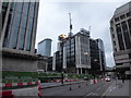
5
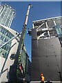
Cladding going up on new building on Moor Lane
This new building is part of the new development between Moor Lane and Moorgate.
Image: © Martyn Pattison
Taken: 10 Aug 2022
0.03 miles
6
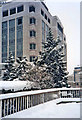
Moorfields Highwalk, London EC2 in the snow
Another part of the Moorfields Highwalk taken in the heavy snow of February 1991. With the fir trees it looks like Christmas!
Image: © Christine Matthews
Taken: Unknown
0.03 miles
7
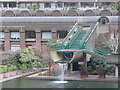
Waterfall, Barbican
Water flowing out of a concrete runnel, built in good sympathy with the adjacent architecture of the apartments.
Image: © Colin Smith
Taken: 2 Jan 2011
0.03 miles
8
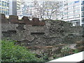
Site of St Alphage, London Wall
Demolished in 1924 https://en.wikipedia.org/wiki/St_Alphege_London_Wall only a tiny plaque tells the passer by a church was ever here.
Image: © Basher Eyre
Taken: 28 Dec 2007
0.03 miles
9
A-spiring to find a hundred churches (62)
Looking towards St Alphage London Wall, where lies buried Rowland Hayward https://en.wikipedia.org/wiki/Rowland_Hayward twice Lord Mayor of London (1570 and 1591: twice married he had 16 children).
Image: © Basher Eyre
Taken: 20 Nov 2016
0.03 miles
10
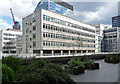
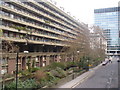
11 Moorfields Highwalk
An office block dating probably from the 1960s with bands of abstract shapes carved below the windows. It appears to be empty and may, like much else built in that most tainted of decades, be due for demolition.
To its right is a bit of a telephone exchange (Image]) and, beyond, a bit of City Tower (Image]).
The shot is taken from one of the walkways on the Barbican Estate.
Image: © Stephen Richards
Taken: 14 May 2011
0.03 miles