IMAGES TAKEN NEAR TO
Wallside, Barbican, LONDON, EC2Y 8BH
Introduction
This page details the photographs taken nearby to Wallside, Barbican, EC2Y 8BH by members of the Geograph project.
The Geograph project started in 2005 with the aim of publishing, organising and preserving representative images for every square kilometre of Great Britain, Ireland and the Isle of Man.

There are currently over 7.5m images from over14,400 individuals and you can help contribute to the project by visiting https://www.geograph.org.uk
Image Map (Loading...)


Getting Data...Please wait
Leaflet Map data © OpenStreetMap
Images are licensed for reuse under creativecommons.org/licenses/by-sa/2.0
Notes
- Clicking on the map will re-center to the selected point.
- The higher the marker number, the further away the image location is from the centre of the postcode.
Image Listing (2523 Images Found)
Images are licensed for reuse under creativecommons.org/licenses/by-sa/2.0
Image
Details
Distance
1
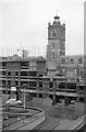
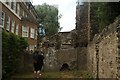
Monkwell Square and St Giles-without-Cripplegate ? 1966
Part of the iconic Barbican Estate https://en.wikipedia.org/wiki/Barbican_Estate developed between 1966 and 1975 as redevelopment of heavily bombed areas. The building under construction is Wallside. The barbican Estate is Listed Grade II as a single entity, and the landscaping is recognised separately, Listed Grade II Park & Garden.
St Giles is one of the few surviving medieval churches of London. The body of the church is mid 16th century, added to an earlier tower of c.1400. The upper brick stage of the tower was added 1683-4. The church was fire-gutted during the blitz and later rebuilt using the plans for the 16th century rebuilding. Listed Grade I.
Image: © Alan Murray-Rust
Taken: 27 Apr 1966
0.00 miles
3
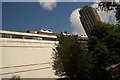
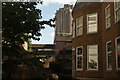
View of 140 London Wall, the domes of Andrewes House and one of the Barbican Towers from the area near the underground car park
Looking north-northwest.
Image: © Robert Lamb
Taken: 25 Jul 2015
0.01 miles
4

View of 55 Silk Street from the area near the underground car park near the Museum of London
Looking north-northeast.
Image: © Robert Lamb
Taken: 25 Jul 2015
0.01 miles
5
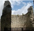
View of two of the Barbican Towers towering above the ruins of the London Wall from the area near the Barbican Estate #3
Looking north-northwest.
Image: © Robert Lamb
Taken: 22 Apr 2017
0.01 miles
6
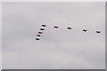
The RAF at 100
Flypast seen from St.Paul's Cathedral.
The Red Arrows, the final section of the 100 aeroplane and helicopter display.
Image: © Peter Trimming
Taken: 10 Jul 2018
0.01 miles
7
View of a section of the London Wall from the area near the underground car park near the Museum of London #34
Looking north-northwest.
Image: © Robert Lamb
Taken: 25 Jul 2015
0.01 miles
8
View of one of the Barbican Towers from the area near the underground car park near the Museum of London #2
Looking north-northeast.
Image: © Robert Lamb
Taken: 25 Jul 2015
0.01 miles
9
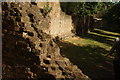
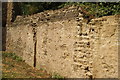
View of the ruins of the London Wall from the area near the Barbican Estate
Looking north-northeast.
Image: © Robert Lamb
Taken: 25 Jul 2015
0.02 miles
10
View of the ruins of the London Wall from the area near the Barbican Estate #2
Looking north-northeast.
Image: © Robert Lamb
Taken: 25 Jul 2015
0.02 miles