IMAGES TAKEN NEAR TO
King Street, LONDON, EC2V 8BB
Introduction
This page details the photographs taken nearby to King Street, EC2V 8BB by members of the Geograph project.
The Geograph project started in 2005 with the aim of publishing, organising and preserving representative images for every square kilometre of Great Britain, Ireland and the Isle of Man.

There are currently over 7.5m images from over14,400 individuals and you can help contribute to the project by visiting https://www.geograph.org.uk
Image Map
Images are licensed for reuse under creativecommons.org/licenses/by-sa/2.0
Notes
- Clicking on the map will re-center to the selected point.
- The higher the marker number, the further away the image location is from the centre of the postcode.
Image Listing (3818 Images Found)
Images are licensed for reuse under creativecommons.org/licenses/by-sa/2.0
Image
Details
Distance
1

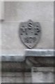
Old Boundary Marker, King Street EC2
Parish Boundary Marker by the UC road, in City of London (City of London District), King Street EC2, high on wall of Kings House, West side of road, right of CL_SMBW01pb Image
Inscription reads:-
ST
L J
19 04
Surveyed
Milestone Society National ID: CL_SLJ02pb
Image: © Milestone Society
Taken: Unknown
0.01 miles
2
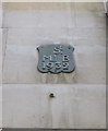
Old Boundary Marker by King Street, City of London
Parish Boundary Marker by the UC road, in City of London (City of London District), King Street EC2, high on wall of Kings House, West side of road, left of CL_SLJ02pb Image
Inscription reads:-
St.
ML' B
1932
Surveyed
Milestone Society National ID: CL_SMBW01pb
Image: © Milestone Society
Taken: Unknown
0.01 miles
3
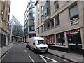
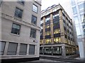
The City- go west young man (47)
Looking from King Street into Trump Street.
And beyond Trump Street? Russia Row- you couldn't make it up!
Image: © Basher Eyre
Taken: 16 Nov 2019
0.01 miles
4
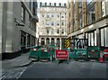
The City: banking on better weather (31)
Looking from Russia Row towards Trump Street. Not a metaphor for US politics https://www.americanprogress.org/article/following-the-money/ just a road closed in the City of London!
Image: © Basher Eyre
Taken: 11 Sep 2023
0.01 miles
5
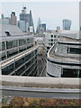
Trump Street and city roofs, view from One Wood Street
The view is along Trump Street. The tower on the right is the "Walkie Talkie", going left buildings include 54 Lombard Street, Lloyd's building, and the "Cheesegrater". The roof garden of Eversheds Sutherland was open for Open Garden Squares weekend.
Image: © David Hawgood
Taken: 9 Jun 2018
0.01 miles
6
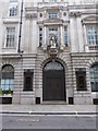
The City- go west young man (45)
Atlas House http://ornamentalpassions.blogspot.com/2012/03/atlas-house-king-street-ec2.html
Image: © Basher Eyre
Taken: 16 Nov 2019
0.01 miles
7
The Square Mile in one day (winter 178)
Image: © Basher Eyre
Taken: 20 Nov 2016
0.01 miles
8
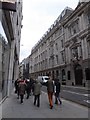
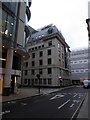
The City- go west young man (44)
King Street, walking north
Image: © Basher Eyre
Taken: 16 Nov 2019
0.01 miles
9
Old Boundary Marker by King Street, City of London
Parish Boundary Marker by the UC road, in parish of City of London (City of London District), King Street EC2, high on wall of bank building, middle of building, East side of road.
Surveyed
Milestone Society National ID: CL_SMP06pb
Image: © Milestone Society
Taken: Unknown
0.01 miles
10
The Square Mile in one day (winter 176)
Trump Street- he's not even been inaugurated and already The City has named a street after him
Image: © Basher Eyre
Taken: 20 Nov 2016
0.01 miles