IMAGES TAKEN NEAR TO
Aldermanbury Square, LONDON, EC2V 7BP
Introduction
This page details the photographs taken nearby to Aldermanbury Square, EC2V 7BP by members of the Geograph project.
The Geograph project started in 2005 with the aim of publishing, organising and preserving representative images for every square kilometre of Great Britain, Ireland and the Isle of Man.

There are currently over 7.5m images from over14,400 individuals and you can help contribute to the project by visiting https://www.geograph.org.uk
Image Map (Loading...)


Getting Data...Please wait
Leaflet Map data © OpenStreetMap
Images are licensed for reuse under creativecommons.org/licenses/by-sa/2.0
Notes
- Clicking on the map will re-center to the selected point.
- The higher the marker number, the further away the image location is from the centre of the postcode.
Image Listing (2651 Images Found)
Images are licensed for reuse under creativecommons.org/licenses/by-sa/2.0
Image
Details
Distance
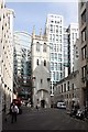
1
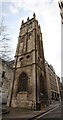
Tower of St Alban's Church, Wood Street, London EC2
Image: © John Salmon
Taken: 17 Mar 2009
0.01 miles
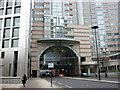
2
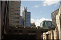
View of 88 Wood Street, 3 Noble Street and One London Wall from the Barbican Estate
Looking south-southwest.
Image: © Robert Lamb
Taken: 25 Jul 2015
0.01 miles
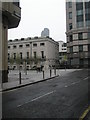
3
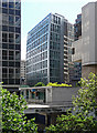
5 Aldermanbury Square
Also known as Royex House, and replacing the previous version by Seifert. This was built in 2004-07 to the designs of Eric Parry. The 2,500-ton stainless steel exterior enables interiors without supporting columns. The building curves towards the top, employing a technique known as entasis, also used by the Greeks to create more aesthetically pleasing curves by counteracting optical illusions. Information from skyscrapernews.com.
Peeking in at the sides are St Alphage House (Image]) and Salters' Hall (Image]).
Image: © Stephen Richards
Taken: 14 May 2011
0.01 miles
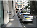
4
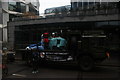
View of an army truck assembled for the Lord Mayor's Parade on London Wall #4
Looking south-southwest.
Image: © Robert Lamb
Taken: 11 Nov 2017
0.01 miles
5
Tower of St Alban's Church, Wood Street, London EC2
Image: © John Salmon
Taken: 17 Mar 2009
0.02 miles
7
Looking from Aldermanbury into Basinghall Street
Taken on the Pepys Walk, a circular walk around the City of London and the South bank starting and finishing at St Paul's Cathedral.
Image: © Basher Eyre
Taken: 17 Apr 2009
0.02 miles
9
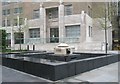
Fountain not working in Aldermanbury
Taken on the Pepys Walk, a circular walk around the City of London and the South bank starting and finishing at St Paul's Cathedral.
Image: © Basher Eyre
Taken: 17 Apr 2009
0.02 miles
10
Plaque in Aldermanbury
Taken on the Pepys Walk, a circular walk around the City of London and the South bank starting and finishing at St Paul's Cathedral.
Image: © Basher Eyre
Taken: 17 Apr 2009
0.02 miles