IMAGES TAKEN NEAR TO
Bartholomew Lane, LONDON, EC2N 2AX
Introduction
This page details the photographs taken nearby to Bartholomew Lane, EC2N 2AX by members of the Geograph project.
The Geograph project started in 2005 with the aim of publishing, organising and preserving representative images for every square kilometre of Great Britain, Ireland and the Isle of Man.

There are currently over 7.5m images from over14,400 individuals and you can help contribute to the project by visiting https://www.geograph.org.uk
Image Map (Loading...)


Getting Data...Please wait
Leaflet Map data © OpenStreetMap
Images are licensed for reuse under creativecommons.org/licenses/by-sa/2.0
Notes
- Clicking on the map will re-center to the selected point.
- The higher the marker number, the further away the image location is from the centre of the postcode.
Image Listing (3433 Images Found)
Images are licensed for reuse under creativecommons.org/licenses/by-sa/2.0
Image
Details
Distance
1
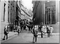
Throgmorton Street, outside the Stock Exchange, Summer 1955
Central confines of The City.
Image: © Ben Brooksbank
Taken: 14 Jul 1955
0.00 miles
2
Sunlit building at the east end of Lothbury
One significant advantage of modern glass and steel buildings is that they can cast some excellent light onto other buildings in the city. In this case the road is shadowed from the low winter sun by the buildings of the Bank of England building to the south but the building beyond is lit indirectly from one of the newer buildings.
Image: © Doug Lee
Taken: 11 Dec 2016
0.00 miles
3
The Square Mile in one day (winter 132)
Note the City of London markers
Image: © Basher Eyre
Taken: 20 Nov 2016
0.01 miles
4
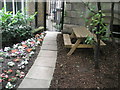
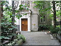
Picnic area within churchyard of St Olave Jewry
Image: © Basher Eyre
Taken: 12 Jul 2008
0.01 miles
5
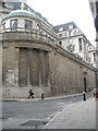
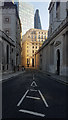
Looking from Throgmorton Street onto the Bank of England
Image: © Basher Eyre
Taken: 13 Aug 2008
0.01 miles
6
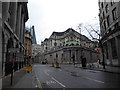
A-spiring to find a hundred churches (42)
Here we see the fortress that is the Bank of England, as in "Safe as__" But in 1781 this area was a discrete parish St Christopher le Stocks https://en.wikipedia.org/wiki/St_Christopher_le_Stocks After the Gordon Riots it was decided to demolish it, and thus avoid anarchists using its structure to gain access to the "Old Lady"! Thus a church, rebuilt after The Great Fire lasted only another century
Image: © Basher Eyre
Taken: 20 Nov 2016
0.01 miles
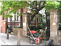
7
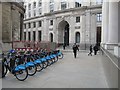
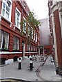
Barclays Bikes, Bartholomew Lane
looking towards the junction with Lothbury
Image: © Rich Tea
Taken: 1 Apr 2011
0.01 miles
8
Entrance to the churchyard of St Olave Jewry
Image: © Basher Eyre
Taken: 12 Jul 2008
0.01 miles
9
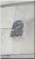
Old Boundary Marker on Bank of Building, Lothbury, City of London
Parish Boundary Marker by the UC road, in parish of City of London (City of London District), Lothbury EC2, at corner with Bartholomew Lane, high on wall of Bank of England, behind pillar (left mark, lower).
Surveyed
Milestone Society National ID: CL_SML02pb
Image: © Milestone Society
Taken: Unknown
0.01 miles