IMAGES TAKEN NEAR TO
Central Street, LONDON, EC1V 8BY
Introduction
This page details the photographs taken nearby to Central Street, EC1V 8BY by members of the Geograph project.
The Geograph project started in 2005 with the aim of publishing, organising and preserving representative images for every square kilometre of Great Britain, Ireland and the Isle of Man.

There are currently over 7.5m images from over14,400 individuals and you can help contribute to the project by visiting https://www.geograph.org.uk
Image Map
Images are licensed for reuse under creativecommons.org/licenses/by-sa/2.0
Notes
- Clicking on the map will re-center to the selected point.
- The higher the marker number, the further away the image location is from the centre of the postcode.
Image Listing (382 Images Found)
Images are licensed for reuse under creativecommons.org/licenses/by-sa/2.0
Image
Details
Distance
1
Geffrye meets his Waterloo (187)
Looking from Lever Street into King Square
Image: © Basher Eyre
Taken: 2 Apr 2016
0.02 miles
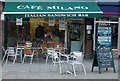
2

View of street art on the wall of The Corner Bar on Central Street
Looking south-southwest.
Image: © Robert Lamb
Taken: 27 Jun 2021
0.02 miles
5
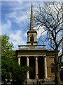
St Clement with St Barnabas & St Matthew, Finsbury
This church was built in 1861 by Thomas Hardwick. It overlooks King Square - a patch of greenery - but is surrounded by King Square Estate of 'sixties tower blocks.
Image: © Stephen McKay
Taken: 6 May 2009
0.03 miles
6
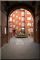
Entrance to courtyard, Chadworth House, St Luke's
Image: © Jim Osley
Taken: 3 Feb 2017
0.03 miles
8
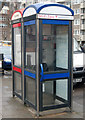
Blue and red phoneboxes, Central Street, London EC1
Image: © Andy F
Taken: 2 Feb 2010
0.03 miles
9

Four Tower cranes in Finsbury
Large construction site south of Lever Road.
See http://www.mountanvil.com/en/our_developments/index.cfm/did/D5650032-5AEC-42F8-AA7C25B4BDEAB0A8 for more details on the site.
Image: © David Anstiss
Taken: 18 Aug 2010
0.04 miles
10
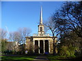
St Clement's Church from King Square Gardens
King Square was originally laid out between 1822 and 1825 on land belonging to St Bartholomew’s Hospital, with the church of St Barnabas built on the east side by 1826. The church was badly damaged during the Second World War but was rebuilt and re-opened in 1956, and later renamed St Clement’s Church. It is in the Parish of St Clement with St Barnabas and St Matthew.
By the 1950s the area was run-down and a new housing estate was planned. The King Square Estate was built for Finsbury Borough Council between 1959 and 1965 and the garden square was re-landscaped and kept as public open space surrounded by the new estate. Over half a million pounds has recently been spent on improvements to the park.
Image: © Marathon
Taken: 19 Dec 2013
0.04 miles