IMAGES TAKEN NEAR TO
St. John Street, LONDON, EC1V 4UB
Introduction
This page details the photographs taken nearby to St. John Street, EC1V 4UB by members of the Geograph project.
The Geograph project started in 2005 with the aim of publishing, organising and preserving representative images for every square kilometre of Great Britain, Ireland and the Isle of Man.

There are currently over 7.5m images from over14,400 individuals and you can help contribute to the project by visiting https://www.geograph.org.uk
Image Map
Images are licensed for reuse under creativecommons.org/licenses/by-sa/2.0
Notes
- Clicking on the map will re-center to the selected point.
- The higher the marker number, the further away the image location is from the centre of the postcode.
Image Listing (994 Images Found)
Images are licensed for reuse under creativecommons.org/licenses/by-sa/2.0
Image
Details
Distance
1
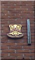
Old Boundary Marker by the B501, St John Street, Finsbury Parish
Parish Boundary Marker by the B501, in parish of Finsbury (Islington District), St John Street EC1, on wall at corner with Great Sutton Street. An identical plaque is just around the corner in Great Sutton Street: MX_CHART02pb Image
Inscription reads:-
CHARTERHOUSE
Surveyed
Milestone Society National ID: MX_CHART01pb
Image: © Milestone Society
Taken: Unknown
0.01 miles
2
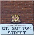
Old Boundary Marker by Great Sutton Street, Finsbury Parish
Parish Boundary Marker by the UC road, in parish of Finsbury (Islington District), Great Sutton Street EC1, on wall at corner with the B501, St John Street.
Surveyed
Milestone Society National ID: MX_CHART02pb
Image: © Milestone Society
Taken: Unknown
0.01 miles
3
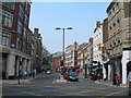
St John Street, EC1 (2)
Image: © Danny P Robinson
Taken: 27 Apr 2007
0.02 miles
4
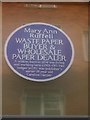
"Blue plaque" on Great Sutton Street, EC1
One of an increasing number of "blue plaques", modelled on those for famous individuals, that tell the story of ordinary citizens, this draws on the 1911 Census to record that in that year this site was occupied by Mary Ann Ruffell, waste paper buyer and wholesale paper dealer, together with her lodger Caroline Harper, a publisher's sorter.
The "plaque" can be seen in context at Image
Image: © Christopher Hilton
Taken: 18 Feb 2020
0.02 miles
5
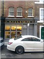
Shop on Great Sutton Street, EC1
Above the door is one of an increasing number of "blue plaques", modelled on those for famous individuals, that tell the story of ordinary citizens. This "plaque" can be seen in detail at Image
Image: © Christopher Hilton
Taken: 18 Feb 2020
0.02 miles
7
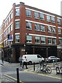
Former Cannon Brewery building, St John Street
For further research on the Cannon Brewery visit this http://www.aim25.ac.uk/cgi-bin/vcdf/detail?coll_id=14595&inst_id=118&nv1=search&nv2=
Image: © Jim Osley
Taken: 28 Sep 2011
0.04 miles
8
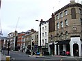
St John Street
At the crossroads with Clerkenwell Road. St John Street, the B501, leads north towards the Angel.
Image: © Derek Harper
Taken: 16 Oct 2007
0.04 miles
9
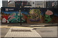
View of a mural on a construction hoarding on Great Sutton Street from Goswell Road #2
Looking south-southwest.
Image: © Robert Lamb
Taken: 12 Sep 2020
0.04 miles
10
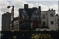
View of a mural on the rear of the office block on Clerkenwell Road from Goswell Road
Looking south-southwest.
Image: © Robert Lamb
Taken: 12 Sep 2020
0.04 miles