IMAGES TAKEN NEAR TO
Norman Street, LONDON, EC1V 3PT
Introduction
This page details the photographs taken nearby to Norman Street, EC1V 3PT by members of the Geograph project.
The Geograph project started in 2005 with the aim of publishing, organising and preserving representative images for every square kilometre of Great Britain, Ireland and the Isle of Man.

There are currently over 7.5m images from over14,400 individuals and you can help contribute to the project by visiting https://www.geograph.org.uk
Image Map
Images are licensed for reuse under creativecommons.org/licenses/by-sa/2.0
Notes
- Clicking on the map will re-center to the selected point.
- The higher the marker number, the further away the image location is from the centre of the postcode.
Image Listing (434 Images Found)
Images are licensed for reuse under creativecommons.org/licenses/by-sa/2.0
Image
Details
Distance
1
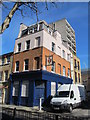
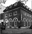
The (former) Langton Arms, Norman Street, EC1
The pubs history site says that the pub closed in 1989 http://pubshistory.com/LondonPubs/StLuke/LangtonArms.shtml .
Image: © Mike Quinn
Taken: 5 Mar 2014
0.01 miles
2
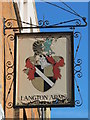
Sign for the (former) Langton Arms, Norman Street, EC1
See Image
Image: © Mike Quinn
Taken: 5 Mar 2014
0.01 miles
3
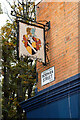
St Lukes : pub sign, Norman Street
Surviving sign for the "Langton Arms" public house which closed in about 1989.
More at this https://www.pubology.co.uk/pubs/4130.html.
Image: © Jim Osley
Taken: 20 Oct 2020
0.01 miles
4
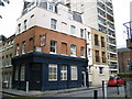
Shoreditch: The former Langton Arms public house
To be found on the corner of Norman Street and with the address of 22 Norman Buildings this was formerly a Bass Charrington house which has now been converted to residential use.
Image: © Nigel Cox
Taken: 25 Sep 2008
0.02 miles
5
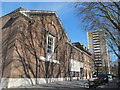
Ironmonger Row Baths (Norman Street side)
The baths, built in 1931, re-opened in November 2012 after extensive refurbishment that cost £16.5 million (funded by Islington Council and EC1 New Deal for Communities); for more info see the LB of Islington site http://www.islington.gov.uk/involved/consultation-engagement/consultationresults/Pages/irb.aspx .
Image: © Mike Quinn
Taken: 5 Mar 2014
0.03 miles
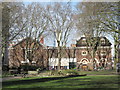
7
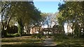
Ironmonger Row Baths, looking up the garden behind St Luke's Old Street
Image: © Christopher Hilton
Taken: 14 Sep 2016
0.03 miles
9
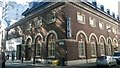
Ironmonger Row Baths
Originally built in 1931 to provide washing facilities for the residents of the former Borough of Finsbury, and subsequently considerably enlarged. Upgraded and refurbished in 2012. Grade II listed building described in detail at this http://list.english-heritage.org.uk/resultsingle.aspx?uid=1391805.
Image: © Jim Osley
Taken: 23 Sep 2013
0.04 miles
10
St Lukes : Ironmonger Row Baths
Grade II listed "public baths, wash-houses and swimming pools. Built in two phases by Finsbury Borough Council. First phase, built 1931, comprised a public baths and washhouse. Architects AWS Cross and KMB Cross. Extended in 1938 to provide a swimming pool, children's pool and Turkish baths, to the design of KMB Cross." - https://historicengland.org.uk/listing/the-list/list-entry/1391805#contributions-banner.
Image: © Jim Osley
Taken: 20 Oct 2020
0.04 miles