IMAGES TAKEN NEAR TO
Clerkenwell Road, LONDON, EC1R 5DQ
Introduction
This page details the photographs taken nearby to Clerkenwell Road, EC1R 5DQ by members of the Geograph project.
The Geograph project started in 2005 with the aim of publishing, organising and preserving representative images for every square kilometre of Great Britain, Ireland and the Isle of Man.

There are currently over 7.5m images from over14,400 individuals and you can help contribute to the project by visiting https://www.geograph.org.uk
Image Map
Images are licensed for reuse under creativecommons.org/licenses/by-sa/2.0
Notes
- Clicking on the map will re-center to the selected point.
- The higher the marker number, the further away the image location is from the centre of the postcode.
Image Listing (857 Images Found)
Images are licensed for reuse under creativecommons.org/licenses/by-sa/2.0
Image
Details
Distance
1
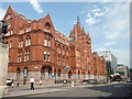
Holdorn Viaduct: Former 'Prudential' building
Probably the largest of Sir Alfred Waterhouse's many buildings for the Prudential Assurance company, this was built in stages from 1879 to 1901.
Image: © Dr Neil Clifton
Taken: 16 Jul 2015
0.01 miles
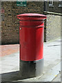
3
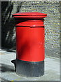
Victorian postbox, Rosebery Avenue, EC1
See also Image
The location of this postbox is shown in Image, Image, Image,
Image, Image, and Image
Image: © Mike Quinn
Taken: 7 Jun 2017
0.01 miles
4
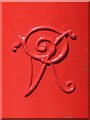
Victorian postbox, Rosebery Avenue, EC1 - royal cipher
See Image
Image: © Mike Quinn
Taken: 7 Jun 2017
0.01 miles
5
Victorian postbox, Rosebery Avenue, EC1 (2)
See also Image
Image: © Mike Quinn
Taken: 7 Jun 2017
0.01 miles
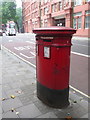
6
Victorian postbox, Rosebery Avenue, EC1 (3)
See Image
Image: © Mike Quinn
Taken: 5 Jul 2017
0.01 miles
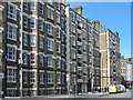
7
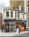
Corner site, Rosebery Avenue/Clerkenwell Road
This building dates from c.1890 according to this http://www.british-history.ac.uk/survey-london/vol47/pp109-139#h2-0006.
Image: © Jim Osley
Taken: 4 Feb 2015
0.01 miles
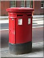
8
London: postbox № EC1 109, Rosebery Avenue
A Victorian double-aperture box, close to the Laystall Street crossroads. In the background we look towards the five-way junction with Grays Inn, Clerkenwell and Theobald's Roads.
Image: © Chris Downer
Taken: 28 Sep 2013
0.01 miles
9
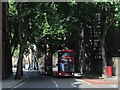
You wait for ages, and ...
Shows the location of Image
Image: © Mike Quinn
Taken: 7 Jun 2017
0.01 miles
10
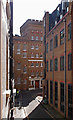
Ragged House, Vine Hill, Clerkenwell
Conversion into residential accommodation of the former Field Lane Ragged School and Night Refuge, built in 1877. More at this http://www.childrenshomes.org.uk/ClerkenwellFieldLane/.
Image: © Jim Osley
Taken: 15 Jun 2016
0.02 miles