IMAGES TAKEN NEAR TO
Bourne Estate, Portpool Lane, LONDON, EC1N 7TY
Introduction
This page details the photographs taken nearby to Bourne Estate, Portpool Lane, EC1N 7TY by members of the Geograph project.
The Geograph project started in 2005 with the aim of publishing, organising and preserving representative images for every square kilometre of Great Britain, Ireland and the Isle of Man.

There are currently over 7.5m images from over14,400 individuals and you can help contribute to the project by visiting https://www.geograph.org.uk
Image Map
Images are licensed for reuse under creativecommons.org/licenses/by-sa/2.0
Notes
- Clicking on the map will re-center to the selected point.
- The higher the marker number, the further away the image location is from the centre of the postcode.
Image Listing (870 Images Found)
Images are licensed for reuse under creativecommons.org/licenses/by-sa/2.0
Image
Details
Distance
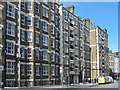
1
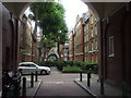
Bourne Estate, off Clerkenwell Rd, London
Image: © John Lord
Taken: 24 Aug 2011
0.01 miles
2
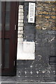
Benchmark beside entrance door to Cavendish Mansions
Ordnance Survey cut mark benchmark described on the Bench Mark Database at http://www.bench-marks.org.uk/bm39297
Image: © Roger Templeman
Taken: 27 Aug 2011
0.01 miles
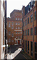
3
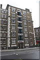
Cavendish Mansions
There is an OS benchmark Image on the white stone to the right of the doors
Image: © Roger Templeman
Taken: 27 Aug 2011
0.01 miles
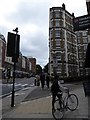
4
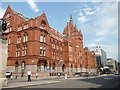
Holdorn Viaduct: Former 'Prudential' building
Probably the largest of Sir Alfred Waterhouse's many buildings for the Prudential Assurance company, this was built in stages from 1879 to 1901.
Image: © Dr Neil Clifton
Taken: 16 Jul 2015
0.02 miles
6
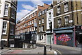
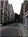
Laystall Street.
This short road runs north west from the Clerkenwell Rd the A5201 close to its junction with the northern end of Leather Lane.
Image: © Nigel Mykura
Taken: 18 Apr 2015
0.02 miles
7
Ragged House, Vine Hill, Clerkenwell
Conversion into residential accommodation of the former Field Lane Ragged School and Night Refuge, built in 1877. More at this http://www.childrenshomes.org.uk/ClerkenwellFieldLane/.
Image: © Jim Osley
Taken: 15 Jun 2016
0.02 miles
8
Junction of Clerkenwell Road and Laystall Street
Image: © Basher Eyre
Taken: 8 Aug 2017
0.02 miles
10
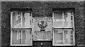
Mazzini commemorative plaque, Laystall Street, Clerkenwell
For more on Mazzini see this http://www.biographyonline.net/politicians/europe/giuseppe-mazzini.html.
Image: © Jim Osley
Taken: 4 Feb 2017
0.03 miles