IMAGES TAKEN NEAR TO
Leather Lane, LONDON, EC1N 7TP
Introduction
This page details the photographs taken nearby to Leather Lane, EC1N 7TP by members of the Geograph project.
The Geograph project started in 2005 with the aim of publishing, organising and preserving representative images for every square kilometre of Great Britain, Ireland and the Isle of Man.

There are currently over 7.5m images from over14,400 individuals and you can help contribute to the project by visiting https://www.geograph.org.uk
Image Map
Images are licensed for reuse under creativecommons.org/licenses/by-sa/2.0
Notes
- Clicking on the map will re-center to the selected point.
- The higher the marker number, the further away the image location is from the centre of the postcode.
Image Listing (1216 Images Found)
Images are licensed for reuse under creativecommons.org/licenses/by-sa/2.0
Image
Details
Distance
2
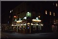
Leigh Place, Holborn
This alley leads through the Victorian Buildings towards Baldwin's Gardens.
Image: © Roger D Kidd
Taken: 23 Mar 2008
0.03 miles
3
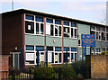
St Alban's Primary School, Holborn
Situated across Baldwin's Gardens opposite the church.
Image: © Roger D Kidd
Taken: 24 Feb 2008
0.03 miles
5
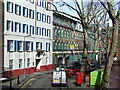
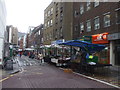
Dorrington Street, Holborn
The picture, taken from the balcony of one of the flats in Brookes Court, shows Brookes Market at the junction of Brooke Street and Dorrington Street. The buildings are used for small businesses and offices. The post box is an Edwardian "double". Image]
Image: © Roger D Kidd
Taken: 12 Apr 2008
0.04 miles
6
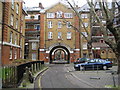
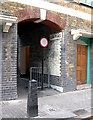
Holborn: The Bourne Estate, EC1
This is the London County Council housing estate built between 1905 and 1909. Ahead are the Nigel Buildings (close-up in Image), to the left are Kirkeby Buildings, and to the right are Laney Buildings with a frontage on the other side on Leather Lane. A burnt out motor scooter resting against the concrete bollards detracts from the view.
Image: © Nigel Cox
Taken: 23 Jan 2008
0.04 miles
7
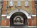
Holborn: Nigel Buildings, The Bourne Estate, EC1
This is a close up view of the arch in Image, looking through to Portpool Lane beyond and then to the arch in Redman Buildings, and then further to the gated courtyard between Radcliff and Scrope Buildings. The whole estate is Grade II listed and was designed in the Free Classical style, with Arts and Crafts touches. It is however beginning to show signs of wear. Note the damp patch on the brickwork below the upper window to the left.
Image: © Nigel Cox
Taken: 23 Jan 2008
0.04 miles
8
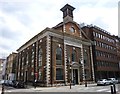
Wren House, Hatton Garden, EC1
Built in the late 1680s, it was originally a chapel - allegedly by Sir Christopher Wren - and became a charity school in 1721. The building suffered bomb damage in WWII and has been rebuilt as offices. Shows the location of Image and Image
Image: © Mike Quinn
Taken: 12 Oct 2011
0.05 miles
9
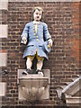
Bluecoat Boy statue, Wren House, Hatton Garden, EC1
Image: © Mike Quinn
Taken: 12 Oct 2011
0.05 miles
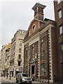
10
Hatton Garden, Wren House
At the corner of St. Cross Street and Hatton Garden; according to the plaque above the entry, built to a Wren design by Lord Hatton after St. Andrew's Holborn burnt down in the Great Fire; later a parish school. There are statues of boy and girl parish scholars above the entrance. The building now contains offices.
Image: © Mike Faherty
Taken: 23 Jun 2012
0.05 miles