IMAGES TAKEN NEAR TO
Charterhouse Square, LONDON, EC1M 6EW
Introduction
This page details the photographs taken nearby to Charterhouse Square, EC1M 6EW by members of the Geograph project.
The Geograph project started in 2005 with the aim of publishing, organising and preserving representative images for every square kilometre of Great Britain, Ireland and the Isle of Man.

There are currently over 7.5m images from over14,400 individuals and you can help contribute to the project by visiting https://www.geograph.org.uk
Image Map
Images are licensed for reuse under creativecommons.org/licenses/by-sa/2.0
Notes
- Clicking on the map will re-center to the selected point.
- The higher the marker number, the further away the image location is from the centre of the postcode.
Image Listing (1703 Images Found)
Images are licensed for reuse under creativecommons.org/licenses/by-sa/2.0
Image
Details
Distance
1
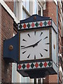
Clock, Carthusian Street, EC1
The location of this clock is shown in Image
Image: © Mike Quinn
Taken: 5 Jul 2011
0.01 miles
3
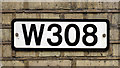
W308
Sign on the wall of the eastbound platform of Image
Image: © Mike Quinn
Taken: 9 Apr 2019
0.01 miles
5
Boundary marker, Carthusian Street, EC1
The location of this boundary marker is shown in Image
Image: © Mike Quinn
Taken: 7 Sep 2011
0.01 miles
6
Former public house, Carthusian Street / Charterhouse Square, EC1
Shows the location of Image
Image: © Mike Quinn
Taken: 7 Sep 2011
0.01 miles
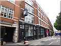
7
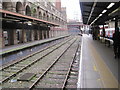
Barbican railway station, Thameslink platform (site), London
Opened in 1865 by the Metropolitan Railway, this southern pair of platforms were used by Great Northern and latterly Thameslink trains from Kings Cross to Moorgate until 2009.
View west towards Farringdon and Kings Cross. The tube platforms to the right are still in use.
Image: © Nigel Thompson
Taken: 13 Nov 2014
0.01 miles
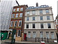
9
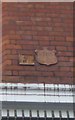
Old Boundary Markers on 41 Charterhouse Square, London EC1
Parish Boundary Markers fixed at first floor level to the north facing wall of No. 41 Charterhouse Square EC1.
On the left is CL_SBWA01pb displaying St / B A and marking the boundary of St Botolph Without Aldersgate.
On the right is MX_SSMP04pb displaying P / St. S.MIDx. / · 1890 · W OVENS / GF …. / LR ALLAN / VESTRY CLERK and marking the boundary of St Sepulchre Middlesex.
Milestone Society National IDs: CL_SBWA01pb and MX_SSMP04pb
Image: © M Faherty
Taken: 11 Jan 2014
0.01 miles
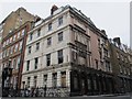
10
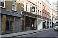
London EC1: The Sutton Arms, Carthusian Street
Image: © Dr Neil Clifton
Taken: 25 Mar 2011
0.02 miles