IMAGES TAKEN NEAR TO
Britton Street, LONDON, EC1M 5AD
Introduction
This page details the photographs taken nearby to Britton Street, EC1M 5AD by members of the Geograph project.
The Geograph project started in 2005 with the aim of publishing, organising and preserving representative images for every square kilometre of Great Britain, Ireland and the Isle of Man.

There are currently over 7.5m images from over14,400 individuals and you can help contribute to the project by visiting https://www.geograph.org.uk
Image Map
Images are licensed for reuse under creativecommons.org/licenses/by-sa/2.0
Notes
- Clicking on the map will re-center to the selected point.
- The higher the marker number, the further away the image location is from the centre of the postcode.
Image Listing (1544 Images Found)
Images are licensed for reuse under creativecommons.org/licenses/by-sa/2.0
Image
Details
Distance
1
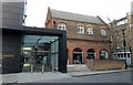
Goldsmiths' Centre
The entrance to the Goldsmiths' Centre from Britton Street in Clerkenwell. The centre was established by the Goldsmiths' livery company and provides for the professional training of goldsmiths.
Image: © Chris Wood
Taken: 20 Jan 2019
0.01 miles
2
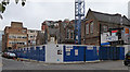
Albion Place
Construction of the Goldsmiths' Centre, an "education and training facility, promoting excellence in the design and manufacture of jewellery and silversmithing." It is funded by the Goldsmiths' Company. I think some modern college buildings went, and former Victorian board school buildings on the right are being incorporated into the development.
Image: © Stephen Richards
Taken: 21 Nov 2010
0.02 miles
3
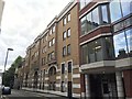
Albion Place in Clerkenwell with Goldsmiths Centre and Janet Street-Porter House
Albion Place in Clerkenwell, seen across Britton Street from the entrance to St John's Gardens. The Goldsmiths Centre is on the right-hand corner and the house built for Janet Street-Porter on the left.
Image: © Chris Wood
Taken: 20 Jan 2019
0.02 miles
5
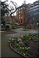
St.John's Clerkenwell
The church has long since disappeared. The churchyard remains as a public garden 'for the quiet enjoyment and refreshment of the living' beside Benjamin Street.
Image: © Martin Addison
Taken: 5 Feb 2008
0.02 miles
6
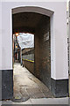
Faulkner's Alley
A narrow path between Benjamin Street and Cowcross Street.
Image: © Martin Addison
Taken: 5 Feb 2008
0.03 miles
7
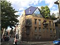
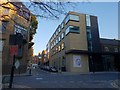
House for Janet Street-Porter at the junction of Albion Place and Britton Street
A house designed by the architect Piers Gough in 1986-1988
Image: © Andrew Abbott
Taken: 8 Sep 2016
0.03 miles
8
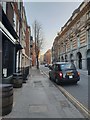
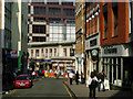
Britton Street, Clerkenwell, looking south
A view looking south along Britton Street, Clerkenwell, London. The Jerusalem Tavern can be seen to the immediate left.
Image: © Chris Wood
Taken: 20 Jan 2019
0.03 miles
9
Cowcross Street, Farringdon
This area, to the south of Clerkenwell, feels thoroughly urban with narrow streets and tall buildings. Its proximity to the City (but with lower rents) has made it a major area for office accommodation; coffee shops and other service businesses have sprung up to serve the needs of the office workers.
Image: © Stephen McKay
Taken: 24 May 2007
0.04 miles
10
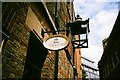
View of The Rookery pub from Peter's Hill
Looking north-northeast.
Image: © Robert Lamb
Taken: 8 Jul 2017
0.04 miles