1
Benchmark on C? Ph?, #47 Clerkenwell Road
Ordnance Survey cut mark benchmark described on the Bench Mark Database at http://www.bench-marks.org.uk/bm39299
Image: © Roger Templeman
Taken: 27 Aug 2011
0.02 miles
2
Vietnamese restaurant, #47 Clerkenwell Road
There is an OS benchmark
Image on the bricks on the right hand side of the building
Image: © Roger Templeman
Taken: 27 Aug 2011
0.02 miles
3
47 Clerkenwell Road Benchmark
Image: © Cipollini
Taken: 20 Aug 2024
0.02 miles
4
The Jerusalem Tavern, Britton St, EC1
Image: © Row17
Taken: 29 Jun 2007
0.02 miles
5
St Johns Path, seen from Britton Street, Clerkenwell
St Johns Path as seen from Britton Street, Clerkenwell, London
Image: © Chris Wood
Taken: 20 Jan 2019
0.02 miles
6
Shops on Clerkenwell Road, London
Image: © JThomas
Taken: 5 Aug 2017
0.03 miles
7
Sign for The Zetter, Clerkenwell Road, EC1
Image: © Mike Quinn
Taken: 17 Feb 2010
0.03 miles
8
"The Jerusalem Tavern" public house, Britton Street
History of the establishment at this https://zythophile.wordpress.com/2010/02/23/the-jerusalem-tavern-clerkenwell-a-short-history/.
Image: © Jim Osley
Taken: 25 Mar 2015
0.03 miles
9
Jerusalem Tavern and St Johns Path, Britton Street, Clerkenwell
The Jerusalem Tavern (right) and St Johns Path (left) in Britton Street, Clerkenwell, London.
Image: © Chris Wood
Taken: 20 Jan 2019
0.03 miles
10
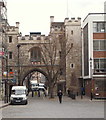
St John's Gate, London, EC1
St John's Gate is easy to miss. It is seen here spanning St John’s Lane, in a corner of St John’s Square, off Old Street. It was built in 1504 as the south entrance to the inner precinct of the Priory of the Knights of Saint John - the Knights Hospitallers. From 1701-09 it was the home of the painter William Hogarth, a child at the time. In 1703 his father Richard opened a coffee house in it named “Hogarth's Coffee House” offering Latin lessons with the coffee. For many years the building was used as a tavern. The gate was acquired in the 1870s by the revived Order of St. John and was gradually converted to serve as headquarters of both the Order and its subsidiary, the St. John Ambulance Brigade. It houses the Museum of the Order too.
Image: © David Hallam-Jones
Taken: 5 Apr 2013
0.03 miles


