IMAGES TAKEN NEAR TO
EC1A 1WT
Introduction
This page details the photographs taken nearby to EC1A 1WT by members of the Geograph project.
The Geograph project started in 2005 with the aim of publishing, organising and preserving representative images for every square kilometre of Great Britain, Ireland and the Isle of Man.

There are currently over 7.5m images from over14,400 individuals and you can help contribute to the project by visiting https://www.geograph.org.uk
Image Map
Images are licensed for reuse under creativecommons.org/licenses/by-sa/2.0
Notes
- Clicking on the map will re-center to the selected point.
- The higher the marker number, the further away the image location is from the centre of the postcode.
Image Listing (850 Images Found)
Images are licensed for reuse under creativecommons.org/licenses/by-sa/2.0
Image
Details
Distance
2
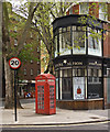
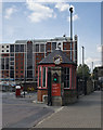
Shop and K2 telephone box, Rosebery Avenue
Image: © Jim Osley
Taken: 23 Apr 2014
0.02 miles
3
Mount Pleasant, King's Cross Road
See https://en.wikipedia.org/wiki/Mount_Pleasant_Mail_Centre .
Image: © Mike Quinn
Taken: 2 May 2018
0.02 miles
4
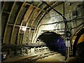
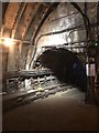
Mail Rail - diverging tunnels
The layout around the Mount Pleasant sorting office is particularly complex, but essentially allows trains from either direction to loop round without having to reverse. Thanks to whoever put the layout on OpenStreetMap for geolocating this underground junction where one large diameter tunnel splits into two smaller ones.
Image: © Stephen Craven
Taken: 1 Jun 2022
0.03 miles
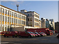
5
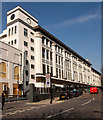
Mount Pleasant Mail Centre
For a history the development of postal services at Mount Pleasant see this http://postalheritage.org.uk/page/mountpleasant. The building in the image was constructed in 1925-1926 to the designs of architect Albert Robert Myers.
Image: © Jim Osley
Taken: 12 Mar 2014
0.03 miles
6
Disused Tunnel to Whitechapel
The Royal Mail used a dedicated 2ft gauge underground railway to move mail between London sorting offices with the largest station centred on Mount Pleasant. Closed in 2003, the loop around Mount Pleasant has been re-opened as a tourist attraction. The image shows the tunnel that took the line towards the eastern Terminus at Whitechapel.
Image: © David Robinson
Taken: 30 Aug 2018
0.03 miles
7
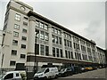
Mount Pleasant sorting office
The largest of Royal Mail's sorting offices in London, this main building was designed by A R Myers and built 1925-1934. There are, or have been, other buildings on the site that was acquired by the Royal Mail in the 1880s, although part of it has been sold for housing development in recent years. Along the side are names of British towns and cities (Rugby, Bath, Wigan...) and above, in smaller letters, districts of London beginning with Clerkenwell where the sorting office is situated.
Image: © Stephen Craven
Taken: 1 Jun 2022
0.03 miles
8
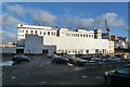
Mount Pleasant sorting office
The British Postal Museum is also housed here.
Image: © Robin Webster
Taken: 21 Nov 2015
0.04 miles
9
Entrance gate, Mount Pleasant Mail Centre
Image: © Jim Osley
Taken: 30 Apr 2014
0.04 miles
10
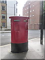
London: new postbox on Rosebery Avenue
This postbox has been positioned here in the last twelve months, outside Image The sorting office is due to undergo considerable development work shortly, which will involve the temporary relocation of the post office branch to a shop across Farringdon Road. This is therefore perhaps a future replacement for postbox № EC1 100, which is currently set within the wall of the building - see Image
The box is not yet operational; its slots are closed by way of a metal barrier affixed to the inside.
Update: Indeed, Julian Osley's photo of Mount Pleasant Post Office in January 2014 Image shows the wall postboxes sealed up with tape - so my theory above has proven to be correct.
Image: © Chris Downer
Taken: 28 Sep 2013
0.04 miles