IMAGES TAKEN NEAR TO
Sewardstone Road, LONDON, E4 7RJ
Introduction
This page details the photographs taken nearby to Sewardstone Road, E4 7RJ by members of the Geograph project.
The Geograph project started in 2005 with the aim of publishing, organising and preserving representative images for every square kilometre of Great Britain, Ireland and the Isle of Man.

There are currently over 7.5m images from over14,400 individuals and you can help contribute to the project by visiting https://www.geograph.org.uk
Image Map (Loading...)


Getting Data...Please wait
Leaflet Map data © OpenStreetMap
Images are licensed for reuse under creativecommons.org/licenses/by-sa/2.0
Notes
- Clicking on the map will re-center to the selected point.
- The higher the marker number, the further away the image location is from the centre of the postcode.
Image Listing (29 Images Found)
Images are licensed for reuse under creativecommons.org/licenses/by-sa/2.0
Image
Details
Distance
1
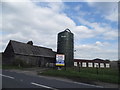
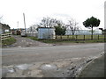
Netherhouse Farm, Chingford
Now empty and up for retail use
Image: © David Howard
Taken: 9 Apr 2014
0.02 miles
2
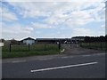
Netherhouse Farm, Chingford
Now up for retail usage and empty
Image: © David Howard
Taken: 9 Apr 2014
0.03 miles
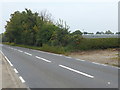
4
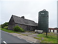
Part of Netherhouse Farm
The road is the A112.
Image: © Robert Edwards
Taken: 23 Apr 2008
0.04 miles
5
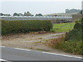
Sewardstone
A glance at the map will tell you that historically Sewardstone's main source of income has been from the growing of vegetables and fruit in glasshouses. This is one of the nurseries on the east side of the A112 Sewardstone Road.
Image: © Nigel Cox
Taken: 24 Jan 2008
0.06 miles
6

Godwin Close at the junction of Sewardstone Road
Image: © David Howard
Taken: 28 Nov 2021
0.07 miles
7
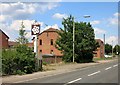
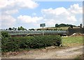
No Pub any More
Still marked with a hopeful PH on my map, there's now nothing left except the sign.
Image: © Des Blenkinsopp
Taken: 24 Jul 2014
0.07 miles
8
Sewardstone Road
This looks across Sewardstone Road to some of the glasshouses on either side of Mott Street. See also http://www.geograph.org.uk/photo/5551930
Image: © Marathon
Taken: 27 Sep 2017
0.09 miles
9
Glasshouses in the Lea Valley
This looks across Sewardstone Road to some of the glasshouses on either side of Mott Street. Thompson's Wood is on top of the hill in the distance.
Image: © Marathon
Taken: 27 Sep 2017
0.10 miles
10
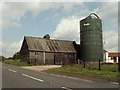
Netherhouse Nursery
There are still quite a lot of glasshouses in this area, although not as many as shown on even quite recent maps.
Image: © Des Blenkinsopp
Taken: 24 Jul 2014
0.13 miles