IMAGES TAKEN NEAR TO
Sewardstone Road, LONDON, E4 7RF
Introduction
This page details the photographs taken nearby to Sewardstone Road, E4 7RF by members of the Geograph project.
The Geograph project started in 2005 with the aim of publishing, organising and preserving representative images for every square kilometre of Great Britain, Ireland and the Isle of Man.

There are currently over 7.5m images from over14,400 individuals and you can help contribute to the project by visiting https://www.geograph.org.uk
Image Map (Loading...)


Getting Data...Please wait
Leaflet Map data © OpenStreetMap
Images are licensed for reuse under creativecommons.org/licenses/by-sa/2.0
Notes
- Clicking on the map will re-center to the selected point.
- The higher the marker number, the further away the image location is from the centre of the postcode.
Image Listing (4 Images Found)
Images are licensed for reuse under creativecommons.org/licenses/by-sa/2.0
Image
Details
Distance
1
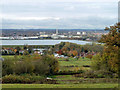
View from Barn Hill
Looking over Sewardstone to the top end of the King George V reservoir and Enfield power station.
Image: © Robin Webster
Taken: 17 Nov 2012
0.01 miles
2
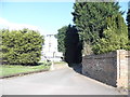
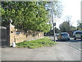
The entrance to Woodlands Stables, Chingford
Image: © David Howard
Taken: 9 Apr 2014
0.11 miles