IMAGES TAKEN NEAR TO
Blandford Crescent, LONDON, E4 7NT
Introduction
This page details the photographs taken nearby to Blandford Crescent, E4 7NT by members of the Geograph project.
The Geograph project started in 2005 with the aim of publishing, organising and preserving representative images for every square kilometre of Great Britain, Ireland and the Isle of Man.

There are currently over 7.5m images from over14,400 individuals and you can help contribute to the project by visiting https://www.geograph.org.uk
Image Map
Images are licensed for reuse under creativecommons.org/licenses/by-sa/2.0
Notes
- Clicking on the map will re-center to the selected point.
- The higher the marker number, the further away the image location is from the centre of the postcode.
Image Listing (69 Images Found)
Images are licensed for reuse under creativecommons.org/licenses/by-sa/2.0
Image
Details
Distance
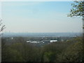
1
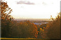
Pole Hill, Chingford, London E4
Looking down Pole Hill towards the south on an exceptionally clear day. Even at the resolution on Geograph some of the skyscrapers can be identified - namely the Gherkin and the former NatWest Tower to the left. Sadly although visible on the original it is not possible to see the London Eye at this resolution although it is quite visible on the original.
Image: © Christine Matthews
Taken: 18 Nov 2008
0.03 miles
2
Pole Hill Road, Chingford
Climbing from a 36 metre spot height at the junction of Kings Head Hill, to about 55 metres at the junction of the houses and the woodland.
Image: © Christine Johnstone
Taken: 11 Jan 2016
0.05 miles
3
Pole Hill, Chingford, London E4
Looking down Pole Hill on this exceptionally clear afternoon, the London skyline could be clearly seen - the Gherkin, former NatWest Tower, The London Eye and the Telecom Tower could all easily be identified with the naked eye.
Image: © Christine Matthews
Taken: 18 Nov 2008
0.08 miles
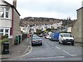
4
Chingford: Pole Hill Road, E4
A steep residential no through road, leading up to Pole Hill and off the A110 Kings Head Hill.
Image: © Nigel Cox
Taken: 5 Jan 2007
0.10 miles
5
View from Pole Hill
Showing the centre of London, with "The Gherkin" and the Post Office Tower distinguishable on the horizon. Closer, are the Lea Valley Reservoirs.
Image: © Danny P Robinson
Taken: 6 Apr 2007
0.10 miles
6
Pole Hill, Chingford, London E4
Looking down Pole Hill with the London skyline in the distance.
Image: © Christine Matthews
Taken: 18 Nov 2008
0.11 miles
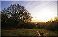
7
Forest Boundary
A tiny sliver of Epping Forest just makes it into TQ3794
Image: © Roger Jones
Taken: 9 Jul 2011
0.12 miles
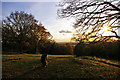
8
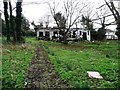
Ruined building and abandoned garden, Chingford
On the south side of Kings Head Hill.
Image: © Christine Johnstone
Taken: 11 Jan 2016
0.12 miles
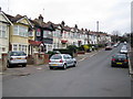
9
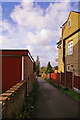
Access road, Woodberry Way, London E4
Access road leading westwards from Woodberry Way.
Image: © Christine Matthews
Taken: 18 Nov 2008
0.13 miles
10
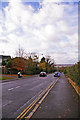
Kings Head Hill (A110) , Chingford, London E4
Looking down Kings Head Hill towards the reservoirs.
Image: © Christine Matthews
Taken: 18 Nov 2008
0.13 miles