IMAGES TAKEN NEAR TO
Whitechapel High Street, LONDON, E1 7QA
Introduction
This page details the photographs taken nearby to Whitechapel High Street, E1 7QA by members of the Geograph project.
The Geograph project started in 2005 with the aim of publishing, organising and preserving representative images for every square kilometre of Great Britain, Ireland and the Isle of Man.

There are currently over 7.5m images from over14,400 individuals and you can help contribute to the project by visiting https://www.geograph.org.uk
Image Map
Images are licensed for reuse under creativecommons.org/licenses/by-sa/2.0
Notes
- Clicking on the map will re-center to the selected point.
- The higher the marker number, the further away the image location is from the centre of the postcode.
Image Listing (1347 Images Found)
Images are licensed for reuse under creativecommons.org/licenses/by-sa/2.0
Image
Details
Distance
1
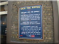
View of the Jack the Ripper plaque on the side wall of the White Hart pub
I'm really surprised that a member of the royal family was suspected to have been Jack the Ripper! The barber/surgeon isn't really surprising though as the murders were carried out in a very anatomical way. Looking south-southwest.
UPDATE SEPTEMBER 2014: The mystery has now been solved! Jack the Ripper happens to be a Polish immigrant called Aaron Kosminkski, who ended up dying in asylum. Read the full story here: http://www.standard.co.uk/news/uk/identity-of-notorious-serial-killer-jack-the-ripper-finally-unveiled-9716900.html It'll be interesting to pay another visit in a month or two to see if this plaque has been updated.
Image: © Robert Lamb
Taken: 4 May 2014
0.01 miles
2
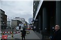
View up Old Castle Street from Whitechapel Road
Looking north-northwest. The footbridge crossing the road is part of the London Metropolitan University.
Image: © Robert Lamb
Taken: 4 May 2014
0.02 miles
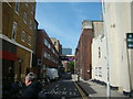
3
View up Old Castle Street from Whitechapel High Street
Looking northwest. The three coloured rectangles above the road in the background is a covered pedestrian walkway, which is part of the London Metropolitan University.
Image: © Robert Lamb
Taken: 3 Nov 2019
0.02 miles
4
View of tower block from the junction of Brushfield and Crispin Streets
This tower block is a little further along Crispin Street at the junction of Wentworth Street and was taken from the junction of Brushfield and Crispin Streets looking south-southeast along Crispin Street. Spitalfields indoor market is just behind the photographer.
Image: © Robert Lamb
Taken: 7 Feb 2010
0.02 miles
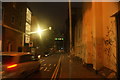
6
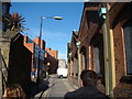
View up Tyne Street
Looking north-northwest.
Image: © Robert Lamb
Taken: 21 Oct 2011
0.02 miles
7
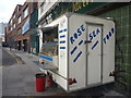
London Cityscape : Seafood Kiosk, Goulston Street, E1
Image: © Richard West
Taken: 1 Oct 2014
0.02 miles
8
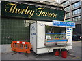
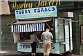
London Cityscape : World Famous Jellied Eels
"With or without winkles, Sir?"
Image: © Richard West
Taken: 1 Oct 2014
0.02 miles
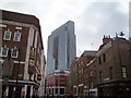
9
View of the Walkie Talkie from Whitechapel High Street
Looking south-southwest.
Image: © Robert Lamb
Taken: 20 Mar 2016
0.02 miles
10
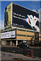
Hoardings
A whole building provides a billboard beside St. Botolph Street.
Image: © Martin Addison
Taken: 13 Feb 2009
0.03 miles