IMAGES TAKEN NEAR TO
Artillery Lane, LONDON, E1 7LP
Introduction
This page details the photographs taken nearby to Artillery Lane, E1 7LP by members of the Geograph project.
The Geograph project started in 2005 with the aim of publishing, organising and preserving representative images for every square kilometre of Great Britain, Ireland and the Isle of Man.

There are currently over 7.5m images from over14,400 individuals and you can help contribute to the project by visiting https://www.geograph.org.uk
Image Map
Images are licensed for reuse under creativecommons.org/licenses/by-sa/2.0
Notes
- Clicking on the map will re-center to the selected point.
- The higher the marker number, the further away the image location is from the centre of the postcode.
Image Listing (1845 Images Found)
Images are licensed for reuse under creativecommons.org/licenses/by-sa/2.0
Image
Details
Distance
1
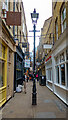
Artillery Lane, Spitalfields
A useful pedestrian lane, with prominent older features such as the converted gas lamp in the centre of this photo.
Image: © Roger Jones
Taken: 5 Apr 2022
0.01 miles
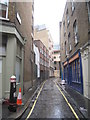
2
Artillery Lane
In the past this lane led to Tasel Close, an area used by the Honourable Artlillery Company.
Long, D. (2021). London’s Secret Square Mile. 2nd ed. Cheltenham: The History Press.
Image: © Basher Eyre
Taken: 12 Oct 2008
0.01 miles
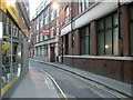
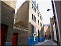
4
Sandys Row (2)
Looking north towards Artillery Lane.
Image: © Jonathan Thacker
Taken: 17 Mar 2012
0.01 miles
5

"Red Church", by Eleonora Aguiari
One of a number of public artworks in around Spitalfields Market.
Image: © Jim Osley
Taken: 10 Mar 2011
0.02 miles
6
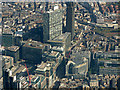
Bishopsgate from the air
The A10 Bishopsgate is in the centre, with Liverpool Street railway station on the left and Spitalfields Market on the right.
Image: © Thomas Nugent
Taken: 26 Aug 2019
0.02 miles
7
Pre-Worboys one-way sign
This sign is on the wall of a building in Artillery Lane, Spitalfields.
Image: © Patrick Mackie
Taken: 30 Jun 2013
0.02 miles
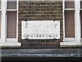
8
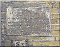
Old Boundary Marker in Brushfield Street, London E1
Parish Boundary Marker by the UC road, in parish of City Of London (City Of London District), Brushfield Street E1, above facade of No 14, left side.
Surveyed
Milestone Society National ID: CL_SBB02pb.
Image: © Milestone Society
Taken: Unknown
0.02 miles
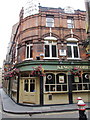
9
Spitalfields, synagogue
Sandys Row Synagogue: originally Huguenot, later Baptist, since 1854 synagogue. http://sandysrow.org.uk/index.php/heritage-culture/
Image: © Mike Faherty
Taken: 15 Sep 2012
0.02 miles
10
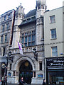
Bishopsgate institute
Opposite Liverpool Street station, the Bishopsgate institute offers courses and also houses a library. Built in 1894.
Image: © David Bradbury
Taken: 12 Nov 2005
0.02 miles