IMAGES TAKEN NEAR TO
Shepherds Brook Road, STOURBRIDGE, DY9 7DX
Introduction
This page details the photographs taken nearby to Shepherds Brook Road, DY9 7DX by members of the Geograph project.
The Geograph project started in 2005 with the aim of publishing, organising and preserving representative images for every square kilometre of Great Britain, Ireland and the Isle of Man.

There are currently over 7.5m images from over14,400 individuals and you can help contribute to the project by visiting https://www.geograph.org.uk
Image Map (Loading...)


Getting Data...Please wait
Leaflet Map data © OpenStreetMap
Images are licensed for reuse under creativecommons.org/licenses/by-sa/2.0
Notes
- Clicking on the map will re-center to the selected point.
- The higher the marker number, the further away the image location is from the centre of the postcode.
Image Listing (60 Images Found)
Images are licensed for reuse under creativecommons.org/licenses/by-sa/2.0
Image
Details
Distance
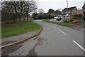
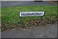
3
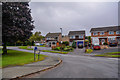
Stourbridge : Fieldfare Road
Looking along Fieldfare Road off Grange Lane.
Image: © Lewis Clarke
Taken: 29 Sep 2019
0.08 miles

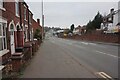
5
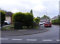
Hay Green
The view in Lye, Dudley.
Image: © Gordon Griffiths
Taken: 11 Jun 2017
0.09 miles
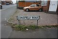
6
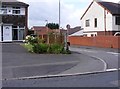
Overman Close
The view from Cemetery Road in Lye, Dudley.
Image: © Gordon Griffiths
Taken: 11 Jun 2017
0.09 miles
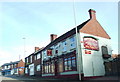
8
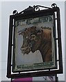
Former Bulls Head on Pedmore Road, Stourbridge
Image: © Ian S
Taken: 17 Dec 2021
0.09 miles