IMAGES TAKEN NEAR TO
Broome, STOURBRIDGE, DY9 0EU
Introduction
This page details the photographs taken nearby to Broome, DY9 0EU by members of the Geograph project.
The Geograph project started in 2005 with the aim of publishing, organising and preserving representative images for every square kilometre of Great Britain, Ireland and the Isle of Man.

There are currently over 7.5m images from over14,400 individuals and you can help contribute to the project by visiting https://www.geograph.org.uk
Image Map (Loading...)


Getting Data...Please wait
Leaflet Map data © OpenStreetMap
Images are licensed for reuse under creativecommons.org/licenses/by-sa/2.0
Notes
- Clicking on the map will re-center to the selected point.
- The higher the marker number, the further away the image location is from the centre of the postcode.
Image Listing (18 Images Found)
Images are licensed for reuse under creativecommons.org/licenses/by-sa/2.0
Image
Details
Distance
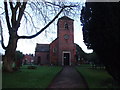
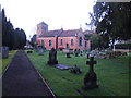
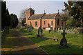
6
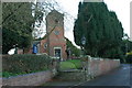
St Peter's Church, Broome
Update of https://www.geograph.org.uk/photo/3790533 from 2013.
Image: © Mike Dodman
Taken: 22 Aug 2024
0.22 miles
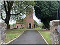
10
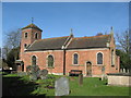
St Peters Church Broome, Worcestershire
The church was built in the late C18, extended 1861 and 1970s and comprises brick with stone dressings and tile roof. It was Grade II listed in 1958.
Image: © Richard Rogerson
Taken: 15 Mar 2009
0.23 miles