IMAGES TAKEN NEAR TO
George Street, STOURBRIDGE, DY8 5TR
Introduction
This page details the photographs taken nearby to George Street, DY8 5TR by members of the Geograph project.
The Geograph project started in 2005 with the aim of publishing, organising and preserving representative images for every square kilometre of Great Britain, Ireland and the Isle of Man.

There are currently over 7.5m images from over14,400 individuals and you can help contribute to the project by visiting https://www.geograph.org.uk
Image Map
Images are licensed for reuse under creativecommons.org/licenses/by-sa/2.0
Notes
- Clicking on the map will re-center to the selected point.
- The higher the marker number, the further away the image location is from the centre of the postcode.
Image Listing (43 Images Found)
Images are licensed for reuse under creativecommons.org/licenses/by-sa/2.0
Image
Details
Distance
1
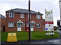
Oakfields development, Lyndhurst Drive
Image: © Alex McGregor
Taken: 1 Nov 2012
0.10 miles
2
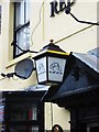
The Red Lion (3) - lamp, 147 Brettell Lane, Amblecote, Stourbridge
This is one of the Banks's houses which has retained a lamp with the Banks's lion, over its front door. Possibly, in late Victorian times, they were lit by gas.
Image
Image
Image: © P L Chadwick
Taken: 5 Jun 2012
0.12 miles
3
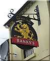
The Red Lion (2) - sign, 147 Brettell Lane, Amblecote, Stourbridge
The sign follows the normal design for Banks's houses, with its golden lion.
The Red Lion remains the most common name given to public houses. The name derives from King James VI of Scotland, who inherited the English throne in 1603, on the death of Queen Elizabeth I. He became King James I of England, and to reinforce his authority to rule, he decreed that all public buildings (including taverns) must display a heraldic red lion in a prominent position. This resulted in many pubs acquiring the Red Lion name. Judging by its appearance, this particular Red Lion pub almost certainly wasn't around in the 17th century, but the tradition of giving this name to pubs seems to have carried on for a long time. According to The Inn Sign Society's website, there are thought to be about 600 Red Lion pubs still in business, and over the years many of the same name have closed.
Image
Image
Image: © P L Chadwick
Taken: 5 Jun 2012
0.12 miles
4
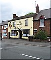
The Red Lion (1), 147 Brettell Lane, Amblecote, Stourbridge
The town of Stourbridge has several pubs called the Red Lion within its various districts. This one is at Amblecote and is a Banks's house. Next door on the left is a computer services shop. This belonged to the same brewery as the pub and was in use as a private house, when planning permission was given in 1991 to convert it to retail premises and offices.
Image
Image
Image: © P L Chadwick
Taken: 5 Jun 2012
0.12 miles
5
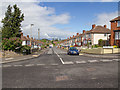
Lydhurst Drive
Looking NNW down Lydhurst Drive from Oak Park Road.
Image: © David P Howard
Taken: 8 May 2013
0.12 miles
6
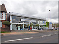
Stourbridge Volkswagen
A motor car dealership on the A491 Camp Hill. http://www.volkswagen.co.uk/retailers/find-us/00690/stourbridge-volkswagen/stourbridge
Image: © David P Howard
Taken: 8 May 2013
0.13 miles
8
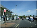
The Glassworks (1), Camphill, Stourbridge
The pub is named the Glassworks, because there used to be glassworks manufacturing factories in the vicinity. Competition from abroad led to factory closures, and some relocations abroad, so that by about 1990 the last factory closed. Today all that is left are museums, including the Red House Glass Cone. The pub itself is food focused, being part of the Brewers Fayre chain, owned by Whitbread the former brewing group.
Image
Image: © P L Chadwick
Taken: 29 Oct 2011
0.16 miles
9
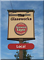
The Glassworks (2) - sign, Camphill, Stourbridge
As so often with pub/restaurant chains like Brewers Fayre, the sign is a corporate design, with no individuality apart from the pub name.
Image
Image: © P L Chadwick
Taken: 29 Oct 2011
0.16 miles
