IMAGES TAKEN NEAR TO
Dowells Gardens, STOURBRIDGE, DY8 5QA
Introduction
This page details the photographs taken nearby to Dowells Gardens, DY8 5QA by members of the Geograph project.
The Geograph project started in 2005 with the aim of publishing, organising and preserving representative images for every square kilometre of Great Britain, Ireland and the Isle of Man.

There are currently over 7.5m images from over14,400 individuals and you can help contribute to the project by visiting https://www.geograph.org.uk
Image Map (Loading...)


Getting Data...Please wait
Leaflet Map data © OpenStreetMap
Images are licensed for reuse under creativecommons.org/licenses/by-sa/2.0
Notes
- Clicking on the map will re-center to the selected point.
- The higher the marker number, the further away the image location is from the centre of the postcode.
Image Listing (55 Images Found)
Images are licensed for reuse under creativecommons.org/licenses/by-sa/2.0
Image
Details
Distance
1
Kingswinford : Cot Lane
Looking along Cot Lane.
Image: © Lewis Clarke
Taken: 28 Sep 2019
0.14 miles
2
Kingswinford : Cot Lane
Looking along Cot Lane.
Image: © Lewis Clarke
Taken: 28 Sep 2019
0.14 miles
3
Kingswinford : Middleway Avenue
Looking along Middleway Avenue off Cot Lane.
Image: © Lewis Clarke
Taken: 28 Sep 2019
0.14 miles
4
Carving of unicorn, entrance to King George V Park, Lawnswood Road, Wordsley, Stourbridge
On the right-hand entrance pillar is this carving of a unicorn. Below are the words "King George's Field". The field is part of the King George V Park.
Image
Image: © P L Chadwick
Taken: 4 Jan 2014
0.15 miles
5
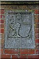
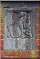
Carving of lion, entrance to King George V Park, Lawnswood Road, Wordsley, Stourbridge
On the left-hand entrance pillar is this carving of a lion. The carving is unfortunately quite weather-worn, so the details originally on the shield are indistinct. King George V reigned from 1910 to 1936 but the dates shown here are 1910 to 1930, presumably because he was still alive at the time the carving was undertaken.
Image
Image: © P L Chadwick
Taken: 4 Jan 2014
0.15 miles
6
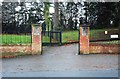
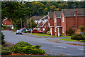
Entrance to King George V Park, Lawnswood Road, Wordsley, Stourbridge
One of several entrances to the park. This one is for pedestrians and authorised vehicles only.
Image
Image
Image: © P L Chadwick
Taken: 4 Jan 2014
0.15 miles
7
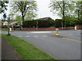
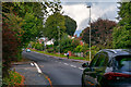
Mini Island
Between Lawnswood Road and Cot Lane.
Image: © Stephen Rogerson
Taken: 21 Apr 2017
0.16 miles
8
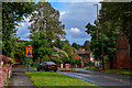
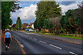
Wordsley : Lawnswood Road
Looking along Lawnswood Road as it approaches the junction with Cot Lane.
Image: © Lewis Clarke
Taken: 28 Sep 2019
0.16 miles
9
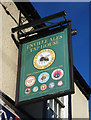
The Queens Head (3) - sign, 129 High Street, Wordsley, Stourbridge
This sign makes no mention of the pub's name, but it does appear on a large sign attached to the pub's front.
Image
Image
Image: © P L Chadwick
Taken: 29 Oct 2011
0.16 miles
10
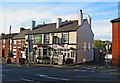
The Queens Head (2), 129 High Street, Wordsley, Stourbridge
Image: © P L Chadwick
Taken: 29 Oct 2011
0.16 miles