
IMAGES TAKEN NEAR TO
Platts Road, STOURBRIDGE, DY8 4YR
Introduction
This page details the photographs taken nearby to Platts Road, DY8 4YR by members of the Geograph project.
The Geograph project started in 2005 with the aim of publishing, organising and preserving representative images for every square kilometre of Great Britain, Ireland and the Isle of Man.

There are currently over 7.5m images from over14,400 individuals and you can help contribute to the project by visiting https://www.geograph.org.uk
Image Map
Images are licensed for reuse under creativecommons.org/licenses/by-sa/2.0
Notes
- Clicking on the map will re-center to the selected point.
- The higher the marker number, the further away the image location is from the centre of the postcode.
Image Listing (83 Images Found)
Images are licensed for reuse under creativecommons.org/licenses/by-sa/2.0
Image
Details
Distance
1
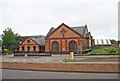
Amblecote Wordsley Methodist Church, High Street, Amblecote, Stourbridge
The local Methodist Church and presumably the church hall alongside.
Image
Image: © P L Chadwick
Taken: 5 Jun 2012
0.04 miles
2

Amblecote Wordsley Methodist Church - welcome sign, High Street, Amblecote, Stourbridge
See:- Image
Image: © P L Chadwick
Taken: 5 Jun 2012
0.05 miles
3
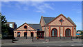
Methodist Church in Amblecote, Dudley
Ablecote Wordsley Methodist Church in Amblecote is situated on the west side of the A491 Audnam by Platts Road.
Image: © Roger D Kidd
Taken: 28 Aug 2010
0.05 miles
4
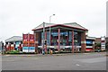
The Crystal Centre, Platts Road, Audnam, Stourbridge
The Crystal Centre is a small retail centre on the corner of Platts Road and Audnam. The centre includes a Tesco Express store, a branch of Bathstore, a branch of Halfords (motoring accessories) and two fast food outlets - KFC and Pizza Hut Delivery.
Image: © P L Chadwick
Taken: 5 Jun 2012
0.06 miles
5
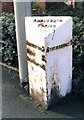
Old Milepost by the A491, Audnam, Amblecote, Dudley parish
Cast iron post by the A491, in parish of Dudley (Dudley District), Amblecote, opposite Brettell Lane junction, by Audnam road, on West side of road. Cochrane iron casting, erected by the County Council in the 20th century.
Inscription reads:-
: KINGSWINFORD 2 / HIMLEY 3½ / WOLVERHAMPTON 9 : : AMBLECOTE / PARISH : : STOURBRIDGE 1 :
Dudley HER.
HER Number: 12536 https://www.heritagegateway.org.uk/Gateway/Results_Single.aspx?uid=MDD2463&resourceID=1038
Milestone Society National ID: ST_WVSB09
Image: © J Higgins
Taken: 1 Feb 2007
0.06 miles
6
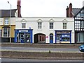
Nos. 2 and 3 High Street, Amblecote, Stourbridge
Located next to the public house now known as the Maverick. The two properties may well have been one in the past. The coach arch could indicate that it was once an hotel or an inn. Today, number 2 on the left is Donovans Music Store, which wells musical instruments. Number 3 is Dawn Crystal, a small family run business which specializes in unique pieces Of English crystal that is hand cut & engraved On The premises.
Image: © P L Chadwick
Taken: 5 Jun 2012
0.06 miles


9
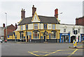
The Maverick (1), 1 High Street, Amblecote, Stourbridge
At some point in the last couple of years, the pub has had a fresh coat of paint, which has considerably enhanced its appearance. It is unusual to find a Jennings Brewery (of Cockermouth, Cumbria) house this far south, but the brewery's acquisition by Marston's in 2005 may have something to do with it. Needless to say, the pub's name is a modern one. The 1911 census shows the pub was then called the White Horse.
Image
Image: © P L Chadwick
Taken: 5 Jun 2012
0.07 miles
10
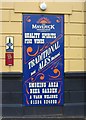
The Maverick (2) - detail, 1 High Street, Amblecote, Stourbridge
This pub, located on the corner of High Street and Brettell Lane, does not have a traditional sign hanging outside, but it has this sign on one wall.
Image
Image: © P L Chadwick
Taken: 5 Jun 2012
0.07 miles