IMAGES TAKEN NEAR TO
Wentworth Road, STOURBRIDGE, DY8 4SD
Introduction
This page details the photographs taken nearby to Wentworth Road, DY8 4SD by members of the Geograph project.
The Geograph project started in 2005 with the aim of publishing, organising and preserving representative images for every square kilometre of Great Britain, Ireland and the Isle of Man.

There are currently over 7.5m images from over14,400 individuals and you can help contribute to the project by visiting https://www.geograph.org.uk
Image Map
Images are licensed for reuse under creativecommons.org/licenses/by-sa/2.0
Notes
- Clicking on the map will re-center to the selected point.
- The higher the marker number, the further away the image location is from the centre of the postcode.
Image Listing (48 Images Found)
Images are licensed for reuse under creativecommons.org/licenses/by-sa/2.0
Image
Details
Distance
1
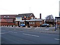
The Barley Mow, Vicarage Road frontage, Wollaston
This pub fronts both Vicarage Road (seen here) and Wollaston's High Street Image A convenient bus shelter adjoins the pub in Vicarage Road. The pub still has signs supplied by Banks's brewery (on both frontages), though that has now been taken over by Marstons.
Image: © P L Chadwick
Taken: 29 Dec 2008
0.11 miles
2
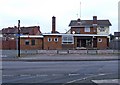
The Barley Mow, 131 High Street, Wollaston
Another of the many pubs in the area, this is unusual in having frontages to two roads, High Street and Vicarage Road.
Image: © P L Chadwick
Taken: 29 Dec 2008
0.11 miles
4

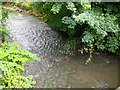
River Stour
View north west from the bridge on the A461 Wollaston Road.
Image: © David P Howard
Taken: 8 May 2013
0.13 miles
5
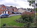
Wollaston Road View
The view from near the canal bridge in Amblecote.
Image: © Gordon Griffiths
Taken: 22 Oct 2017
0.14 miles
6
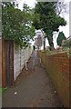
Footpath to High Street, Wollaston, Stourbridge
This footpath links the playing field and open space behind the High Street to that road, which forms part of the A461.
Image: © P L Chadwick
Taken: 6 Jan 2013
0.15 miles
7
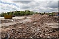
Demolition Site
Looking WSW from the tow path of the Stourbridge Town Arm of the Stourbridge Canal.
The site that is being demolished was occupied by two companies, Caparo Aluminium Technology that closed in March 2012, and Sunrise Medical Limited that moved out in October 2012.
The owners of the site are Halesowen-based developers Revelan Group Ltd., who are planning to build up to 150 new homes. http://www.expressandstar.com/news/2012/04/16/housing-set-for-go-ahead-at-stourbridge-estate/
Image: © David P Howard
Taken: 8 May 2013
0.16 miles
8
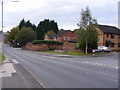
Richardson Drive
The view from the canal bridge on the Wollaston Road, Amblecote.
Image: © Gordon Griffiths
Taken: 20 Oct 2012
0.16 miles
9
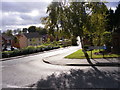
Richardson Drive View
The view near the Stourbridge Canal at Amblecote.
Image: © Gordon Griffiths
Taken: 22 Oct 2017
0.16 miles
10
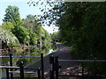
View from Wollaston Road
Looking south along the Stourbridge Canal.
Image: © Gordon Griffiths
Taken: 3 May 2007
0.17 miles