IMAGES TAKEN NEAR TO
Ridgewood Avenue, STOURBRIDGE, DY8 4QH
Introduction
This page details the photographs taken nearby to Ridgewood Avenue, DY8 4QH by members of the Geograph project.
The Geograph project started in 2005 with the aim of publishing, organising and preserving representative images for every square kilometre of Great Britain, Ireland and the Isle of Man.

There are currently over 7.5m images from over14,400 individuals and you can help contribute to the project by visiting https://www.geograph.org.uk
Image Map (Loading...)


Getting Data...Please wait
Leaflet Map data © OpenStreetMap
Images are licensed for reuse under creativecommons.org/licenses/by-sa/2.0
Notes
- Clicking on the map will re-center to the selected point.
- The higher the marker number, the further away the image location is from the centre of the postcode.
Image Listing (12 Images Found)
Images are licensed for reuse under creativecommons.org/licenses/by-sa/2.0
Image
Details
Distance
1
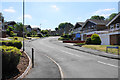
Ridgewood Avenue
A new housing development with fairly uniform design.
Image: © Bill Boaden
Taken: 22 Jun 2018
0.04 miles
2
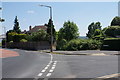
Cul-de-sac off Vicarage Road
The houses on the small housing development retain the numbering of Vicarage Road.
Image: © Bill Boaden
Taken: 22 Jun 2018
0.12 miles
3
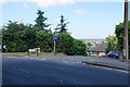
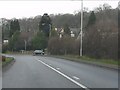
The former top of Meriden Avenue
The road used to go straight down to Wollaston, but has been blocked off.
Image: © Bill Boaden
Taken: 22 Jun 2018
0.13 miles
4
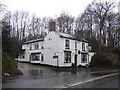
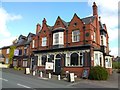
The Foresters
Worthy outlet for Enville Ales. Bang on the Black Country Staffordshire border giving it both urban and rural character.
Image: © al partington
Taken: 9 Jan 2007
0.14 miles
5
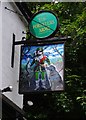
The Foresters Arms (2) - sign, Bridgnorth Road, Wollaston, Stourbridge
On this sign a rather small forester is accompanied by a rather large dog. They both appear to be in some kind of time warp. The forester, who looks like a cousin of Robin Hood, appears to be dressed in a costume that could perhaps be late middle ages, but the dog looks distinctly like a labrador and these didn't really evolve until the 1880's.
Image
Image: © P L Chadwick
Taken: 23 Jun 2012
0.16 miles
6
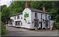
The Foresters Arms (1), Bridgnorth Road, Wollaston, Stourbridge
A popular public house right on the edge of Wollaston. It is believed to have been a public house since the 1800's. There is a large car park at the rear.
Image
Image: © P L Chadwick
Taken: 23 Jun 2012
0.16 miles
7
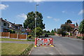
Closed footway on Meriden Avenue
Some work on the street lighting is required. The road has had a much more permanent closure ahead which has stopped it being a rat run.
Image: © Bill Boaden
Taken: 22 Jun 2018
0.17 miles
9
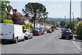
Meriden Avenue
Looking down the slope of this residential street towards the centre of Stourbridge.
Image: © Bill Boaden
Taken: 22 Jun 2018
0.23 miles