IMAGES TAKEN NEAR TO
Church Avenue, STOURBRIDGE, DY8 4JY
Introduction
This page details the photographs taken nearby to Church Avenue, DY8 4JY by members of the Geograph project.
The Geograph project started in 2005 with the aim of publishing, organising and preserving representative images for every square kilometre of Great Britain, Ireland and the Isle of Man.

There are currently over 7.5m images from over14,400 individuals and you can help contribute to the project by visiting https://www.geograph.org.uk
Image Map
Images are licensed for reuse under creativecommons.org/licenses/by-sa/2.0
Notes
- Clicking on the map will re-center to the selected point.
- The higher the marker number, the further away the image location is from the centre of the postcode.
Image Listing (57 Images Found)
Images are licensed for reuse under creativecommons.org/licenses/by-sa/2.0
Image
Details
Distance
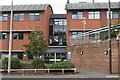
5
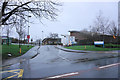
Corbett Outpatients Centre
The only surviving part of Corbett Hospital. Viewed in drizzle.
Image: © Bill Boaden
Taken: 2 Jan 2016
0.11 miles
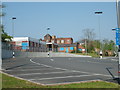
6
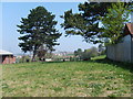
Hospital Field
The land behind the Corbett Hospital.
Image: © Gordon Griffiths
Taken: 15 Apr 2007
0.13 miles
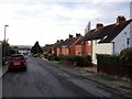
9
Stourbridge Health and Social Care Centre
Image: © David Martin
Taken: 10 Sep 2022
0.14 miles
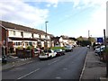
10
Old Corbett Hospital
The old Main Corbett Hospital is now closed and the services moved to Russells Hall Dudley.
Image: © Gordon Griffiths
Taken: 15 Apr 2007
0.14 miles