IMAGES TAKEN NEAR TO
Wollaston Road, STOURBRIDGE, DY8 4HF
Introduction
This page details the photographs taken nearby to Wollaston Road, DY8 4HF by members of the Geograph project.
The Geograph project started in 2005 with the aim of publishing, organising and preserving representative images for every square kilometre of Great Britain, Ireland and the Isle of Man.

There are currently over 7.5m images from over14,400 individuals and you can help contribute to the project by visiting https://www.geograph.org.uk
Image Map
Images are licensed for reuse under creativecommons.org/licenses/by-sa/2.0
Notes
- Clicking on the map will re-center to the selected point.
- The higher the marker number, the further away the image location is from the centre of the postcode.
Image Listing (82 Images Found)
Images are licensed for reuse under creativecommons.org/licenses/by-sa/2.0
Image
Details
Distance
1
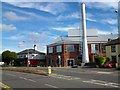
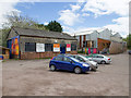
Ruskin Glass Centre
http://ruskinglasscentre.co.uk/
Image: © Stephen Rogerson
Taken: 12 Sep 2013
0.02 miles
2
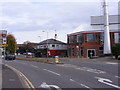
Junction View
The view from Wollaston Road of the junction with the A491 at Amblecote.
Image: © Gordon Griffiths
Taken: 20 Oct 2012
0.04 miles
3
Webb Corbett Visitor Centre
http://ruskinglasscentre.co.uk/history-heritage/
Image: © Stephen Rogerson
Taken: 12 Sep 2013
0.05 miles
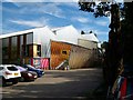
4
The Glasshouse
The view of the Glass Works on Wollaston Road, Amblecote.
Image: © Gordon Griffiths
Taken: 20 Oct 2012
0.05 miles
5
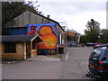
Glasshouse College, Stourbridge
Glasshouse College in Stourbridge is one of three independent specialist further education colleges operated by Ruskin Mill Trust, providing Practical Skill Therapeutic Education for young people aged 16 to 25 years who have a range of learning difficulties, including autistic spectrum disorders and behaviours that challenge.
Founded in September 2000, Glasshouse College is based in a former crystal glassworks in Stourbridge, West Midlands, providing glass-making and glass-cutting, a range of craft workshops, a commercial glass centre, a studio theatre, a public coffee shop, as well as a narrowboat on the Stourbridge canal. http://www.rmt.org/glasshouse/
Image: © David P Howard
Taken: 8 May 2013
0.05 miles
7
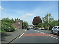
The A491 Amblecote passing Coalbourn Lane
Image: © Roy Hughes
Taken: 3 May 2023
0.06 miles
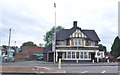
8
The Little Pig (1), 120 High Street, Amblecote, Stourbridge
This is now a Marston's pub but used to be a Burtonwood house, but that pub chain was taken over by Marston's around 2005/2006.
Image
Image: © P L Chadwick
Taken: 5 Jun 2012
0.06 miles
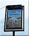
9
The Little Pig (2) - sign, 120 High Street, Amblecote, Stourbridge
The name might seem to be a modern one, but the 1911 census shows a Little Pig Inn in High Street Amblecote, which it seems almost certainly is this one. It has probably been built or rebuilt and extended in the intervening 101 years.
Image
Image: © P L Chadwick
Taken: 5 Jun 2012
0.06 miles
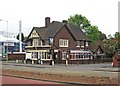
10
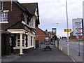
The Little Pig
The view of the Pub on High Street, Amblecote.
Image: © Gordon Griffiths
Taken: 20 Oct 2012
0.06 miles