IMAGES TAKEN NEAR TO
South Road, STOURBRIDGE, DY8 3XZ
Introduction
This page details the photographs taken nearby to South Road, DY8 3XZ by members of the Geograph project.
The Geograph project started in 2005 with the aim of publishing, organising and preserving representative images for every square kilometre of Great Britain, Ireland and the Isle of Man.

There are currently over 7.5m images from over14,400 individuals and you can help contribute to the project by visiting https://www.geograph.org.uk
Image Map (Loading...)


Getting Data...Please wait
Leaflet Map data © OpenStreetMap
Images are licensed for reuse under creativecommons.org/licenses/by-sa/2.0
Notes
- Clicking on the map will re-center to the selected point.
- The higher the marker number, the further away the image location is from the centre of the postcode.
Image Listing (58 Images Found)
Images are licensed for reuse under creativecommons.org/licenses/by-sa/2.0
Image
Details
Distance
1
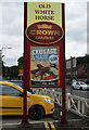
Old White Horse (3) - sign, South Road, Stourbridge
Image: © P L Chadwick
Taken: 16 Aug 2014
0.02 miles
2
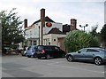
Old White Horse (2), South Road, Stourbridge
Image: © P L Chadwick
Taken: 16 Aug 2014
0.03 miles
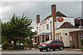
3
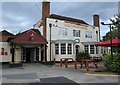
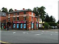
Old White Horse (1), South Road, Stourbridge
A restaurant and public house, part of the Crown Carveries chain. It is a Mitchell & Butlers brand. They used to be a brewing company but now manage a large number of pubs, restaurants and bars under various brand names.
Image
Image
Image: © P L Chadwick
Taken: 16 Aug 2014
0.03 miles
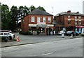
5
One-Stop, Norton Road, Stourbridge
This convenience store is owned by a subsidiary of the supermarket chain Tesco. Next door is the Little Deli Company.
Image: © P L Chadwick
Taken: 16 Aug 2014
0.05 miles
6
Merchants, 117b Worcester Street, Stourbridge
Merchants are a takeaway fish and chip shop and also a restaurant. They also have three branches in Worcestershire.
Image: © P L Chadwick
Taken: 16 Aug 2014
0.06 miles
7
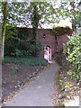
Park Gate
The view of the Gate looking towards Norton Road from Mary Stevens Park, Stourbridge.
Image: © Gordon Griffiths
Taken: 28 Aug 2010
0.07 miles
9
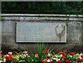
Plaque honouring Frank Edward Foley, outside Mary Stevens Park, Stourbridge
The plaque is to be found in the park's boundary wall near the main gates. It reads, "A tribute to a Stourbridge man who saved many thousands of oppressed people from the Holocaust Frank Edward Foley 1884-1958 Honoured by Israel at Yad Vashem Jerusalem October 1999 as righteous among the nations".
The tree on the right of the plaque was originally coloured brown and the outline of the bird was white but these colours have unfortunately faded somewhat.
The inspiring story of Captain Foley's bravery and of the tens of thousands of lives he helped save from the Nazi's in Germany during the years leading up to the commencement of World War II is too long to set out here, but can easily be found by an internet search for his name.
Image
Image: © P L Chadwick
Taken: 16 Aug 2014
0.10 miles
10
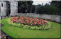
Flowerbed outside Mary Stevens Park, Stourbridge
This flowerbed is one of two outside the main entrance gates to Mary Stevens Park. On the wall, behind the flowerbed, is an interesting commemorative plaque relating to Frank Edward Foley (1884-1958). See:- Image
Image: © P L Chadwick
Taken: 16 Aug 2014
0.10 miles