IMAGES TAKEN NEAR TO
Foster Place, STOURBRIDGE, DY8 3SN
Introduction
This page details the photographs taken nearby to Foster Place, DY8 3SN by members of the Geograph project.
The Geograph project started in 2005 with the aim of publishing, organising and preserving representative images for every square kilometre of Great Britain, Ireland and the Isle of Man.

There are currently over 7.5m images from over14,400 individuals and you can help contribute to the project by visiting https://www.geograph.org.uk
Image Map (Loading...)


Getting Data...Please wait
Leaflet Map data © OpenStreetMap
Images are licensed for reuse under creativecommons.org/licenses/by-sa/2.0
Notes
- Clicking on the map will re-center to the selected point.
- The higher the marker number, the further away the image location is from the centre of the postcode.
Image Listing (132 Images Found)
Images are licensed for reuse under creativecommons.org/licenses/by-sa/2.0
Image
Details
Distance
1
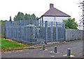
Electricity sub-station near to Foster Place Wollaston
Situated near to the back of houses in Foster Place and adjacent to this lane which leads into Foster Place.
Image: © P L Chadwick
Taken: 27 Sep 2008
0.03 miles
2
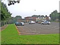
Wollaston Village Hall Community Centre and car park, Wollaston
The name reflects the fact that Wollaston is still in many ways a village though today it is difficult for a stranger to say where it ends and the town of Stourbridge begins. The centre and car park are reached via a service road off Bridgnorth Road. From the outside the centre seems to have seen better days.
Image: © P L Chadwick
Taken: 27 Sep 2008
0.05 miles
3
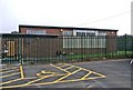
Wollaston Village Hall Community Centre, Wollaston
This is the front of the externally rather undistinguished looking community centre. The door on the left has been boarded up and it is not clear whether the building is currently in use.
Image: © P L Chadwick
Taken: 27 Sep 2008
0.05 miles
4
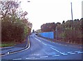
Lowndes Road, Wollaston, Stourbridge
A part industrial and part residential road. This is the industrial end, seen from Bradley Road.
Image: © P L Chadwick
Taken: 16 Oct 2011
0.06 miles
5
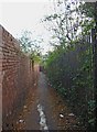
Footpath to Bridgnorth Road, Wollaston
This footpath runs from the playing field behind High Street to Bridgnorth Road Wollaston. On the left is the boundary fence of Wollaston Village Hall Community Centre.
Image: © P L Chadwick
Taken: 27 Sep 2008
0.06 miles
6
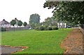
Open space, Bridgnorth Road, Wollaston
This pleasant open space is bounded by Bridgnorth Road and the side of St James's churchyard and extends up to the car park of the Wollaston Village Hall Community Centre. The path on the right carries on past the community centre and gives access to a very large grassed field with football pitches on part of it.
Image: © P L Chadwick
Taken: 27 Sep 2008
0.06 miles
7
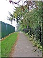
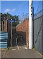
Footpath & cycleway to Bradley Road, Wollaston, Stourbridge
This section of the footpath & cycleway isn't very pleasant. Hemmed in by a high wall on one side and high railings & vegetation on the other, this probably isn't a place to walk on your own, especially at night, as there is no lighting. Another hazard is cyclists, who are supposed to dismount, but many don't.
Image
Image: © P L Chadwick
Taken: 16 Oct 2011
0.08 miles
8
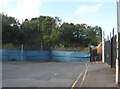
End of Bradley Road, Wollaston, Stourbridge
Showing part of the turning area, and the start of the footpath & cycleway to Kingswinford via High Street Wollaston.
Image
Image
Image: © P L Chadwick
Taken: 16 Oct 2011
0.08 miles
9
Footpath & cycleway from Bradley Road to High Street, Wollaston, Stourbridge
This section of the footpath & cycleway to Kingswinford, via High Street Wollaston, starts here, at the end of Bradley Road. "Cyclists dismount" says the notice, probably more in hope than expectation.
Image
Image: © P L Chadwick
Taken: 16 Oct 2011
0.08 miles
10
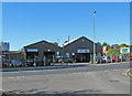
Melrose Motors Ltd & Priestwood Garage Ltd., Bridgnorth Road, Wollaston
Melrose Motors is a used car dealer. Priestwood Garage offers garage services, including MOT testing.
Image: © P L Chadwick
Taken: 25 Sep 2010
0.08 miles