IMAGES TAKEN NEAR TO
South Road, STOURBRIDGE, DY8 3RJ
Introduction
This page details the photographs taken nearby to South Road, DY8 3RJ by members of the Geograph project.
The Geograph project started in 2005 with the aim of publishing, organising and preserving representative images for every square kilometre of Great Britain, Ireland and the Isle of Man.

There are currently over 7.5m images from over14,400 individuals and you can help contribute to the project by visiting https://www.geograph.org.uk
Image Map
Images are licensed for reuse under creativecommons.org/licenses/by-sa/2.0
Notes
- Clicking on the map will re-center to the selected point.
- The higher the marker number, the further away the image location is from the centre of the postcode.
Image Listing (15 Images Found)
Images are licensed for reuse under creativecommons.org/licenses/by-sa/2.0
Image
Details
Distance
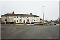
5
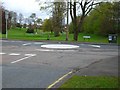
Mini Island
This is between South Road and The Broadway.
Image: © Stephen Rogerson
Taken: 31 Mar 2017
0.10 miles
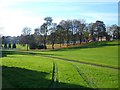
6
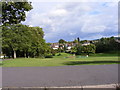
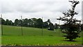
South Road Playing Field
The view off Studley Gate, Stourbridge.
Image: © Gordon Griffiths
Taken: 28 Aug 2010
0.12 miles
8
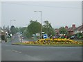
Island of Flowers
Looking down Highpark Avenue from its junction with South Road.
Image: © Gordon Griffiths
Taken: 27 Apr 2007
0.19 miles
10
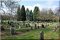
Stourbridge Cemetery and Crematorium
Located on South Road.
Image: © Brian Clift
Taken: 2 Apr 2009
0.19 miles