IMAGES TAKEN NEAR TO
Norton Road, STOURBRIDGE, DY8 2RX
Introduction
This page details the photographs taken nearby to Norton Road, DY8 2RX by members of the Geograph project.
The Geograph project started in 2005 with the aim of publishing, organising and preserving representative images for every square kilometre of Great Britain, Ireland and the Isle of Man.

There are currently over 7.5m images from over14,400 individuals and you can help contribute to the project by visiting https://www.geograph.org.uk
Image Map (Loading...)


Getting Data...Please wait
Leaflet Map data © OpenStreetMap
Images are licensed for reuse under creativecommons.org/licenses/by-sa/2.0
Notes
- Clicking on the map will re-center to the selected point.
- The higher the marker number, the further away the image location is from the centre of the postcode.
Image Listing (12 Images Found)
Images are licensed for reuse under creativecommons.org/licenses/by-sa/2.0
Image
Details
Distance

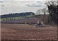
2
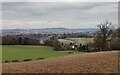
Farmland on the southern edge of Stourbridge
Seven miles away on the horizon is Turner's Hill, the highest point in the West Midlands county, at 271 metres (889 feet).
Image: © Mat Fascione
Taken: 9 Mar 2021
0.15 miles
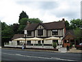
4
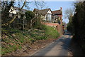
The Crown at Iverley
The rear of the Crown at Iverley viewed from the lane from Churchill.
Image: © Philip Halling
Taken: 31 Mar 2007
0.17 miles
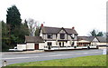
5
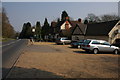
The Crown at Iverley
The Crown at Iverley is on the A451 to the south of Stourbridge.
Image: © Philip Halling
Taken: 31 Mar 2007
0.18 miles
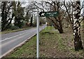
9
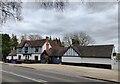
The Crown Inn at Iverley
Along the A451 Kidderminster Road.
Image: © Mat Fascione
Taken: 9 Mar 2021
0.18 miles
10
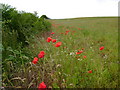
Poppies at field margin
Poppies, bracken, nettles and bramble all flourishing at the edge of a rape seed field.
Image: © Mark Nightingale
Taken: 28 Jun 2011
0.19 miles