IMAGES TAKEN NEAR TO
Hagley Road, STOURBRIDGE, DY8 2JP
Introduction
This page details the photographs taken nearby to Hagley Road, DY8 2JP by members of the Geograph project.
The Geograph project started in 2005 with the aim of publishing, organising and preserving representative images for every square kilometre of Great Britain, Ireland and the Isle of Man.

There are currently over 7.5m images from over14,400 individuals and you can help contribute to the project by visiting https://www.geograph.org.uk
Image Map
Images are licensed for reuse under creativecommons.org/licenses/by-sa/2.0
Notes
- Clicking on the map will re-center to the selected point.
- The higher the marker number, the further away the image location is from the centre of the postcode.
Image Listing (45 Images Found)
Images are licensed for reuse under creativecommons.org/licenses/by-sa/2.0
Image
Details
Distance
1
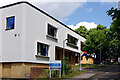
Mary Stevens Hospice
Ernest Stevens, a local Stourbridge benefactor, purchased White Hall in Pedmore together with ten acres of land to establish a maternity home which was given by deed of gift to the borough of Stourbridge in 1931. He named the new maternity home after his wife who had died in 1925. In 1991 a hospice was opened on one part of the property initially offering day care services to the terminally ill. This was later expanded to include a residential unit.
Image: © Stephen McKay
Taken: 21 Jun 2023
0.02 miles
2
The Mary Stevens Hospice and Centre, 221 Hagley Road
The hospice, which includes a day care unit, opened in stages during the 1990's. Previously The Mary Stevens Maternity Home was here, and prior to that a house called Whitehall. Mary Stevens, who died in 1925, was the wife of Ernest Stevens, who was a great benefactor of the town. Stourbridge also has a park named after Mary Stevens.
Image: © P L Chadwick
Taken: 24 Apr 2010
0.04 miles
3

A sign and a poster in Hagley Road
The sign is a permanent feature, but the poster is a temporary one for the 2010 General Election. It is advocating the re-election of Stourbridge's Labour MP Lynda Waltho. She won the seat in 2005 with a small majority of 407.
Image: © P L Chadwick
Taken: 24 Apr 2010
0.05 miles
4
A491 Stourbridge Entrance to Mary Stevens Hospice
Image: © Roy Hughes
Taken: 19 Apr 2014
0.05 miles
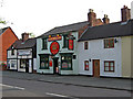
5
The Crown Public House, Old Swinford
Image: © Richard Rogerson
Taken: 13 May 2012
0.06 miles
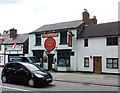
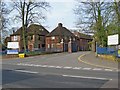
7
The Crown Inn, 208 Hagley Road
Traditional pub, which also offers food. Popular with business people at lunchtimes, and has small outdoor area at back. Next door, on the left, is an upholstery business called English by Tradition.
Image
Image
Image: © P L Chadwick
Taken: 24 Apr 2010
0.06 miles
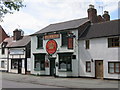
8
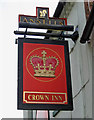
The Crown Inn sign, 208 Hagley Road
This sign is affixed to the front of the pub in Hagley Road. There is a similar sign attached to a post at the entrance to the pub car park in Worcester Lane. It is interesting that the pub still has the Ansells branding. This probably dates from the days when there still was an Ansells brewery in Birmingham. This closed in 1981. Today the brand just about survives, but is brewed in Leeds.
Image
Image
Image: © P L Chadwick
Taken: 24 Apr 2010
0.06 miles
9
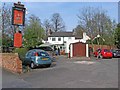
The Crown Inn - rear entrance in Worcester Lane
The pub has a rear entrance in Worcester Lane, which is also the access for the car park. As can be seen, the pub has a second sign here. This is the same design as the one at the front in Hagley Road, and unusually retains the Ansells branding.
Image
Image
Image: © P L Chadwick
Taken: 24 Apr 2010
0.06 miles
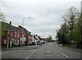
10
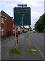
A491 in Oldswinford
As the decaying road sign indicates this is the A491, looking towards Stourbridge town centre. This stretch of road often suffers from congestion as traffic tails back from the traffic lights at Oldswinford Cross, a quarter of mile nearer to Stourbridge.
Image: © Mark Nightingale
Taken: 28 Jun 2008
0.06 miles