IMAGES TAKEN NEAR TO
Scotts Road, STOURBRIDGE, DY8 1UR
Introduction
This page details the photographs taken nearby to Scotts Road, DY8 1UR by members of the Geograph project.
The Geograph project started in 2005 with the aim of publishing, organising and preserving representative images for every square kilometre of Great Britain, Ireland and the Isle of Man.

There are currently over 7.5m images from over14,400 individuals and you can help contribute to the project by visiting https://www.geograph.org.uk
Image Map (209 Images)


Getting Data...Please wait
Leaflet Map data © OpenStreetMap
Images are licensed for reuse under creativecommons.org/licenses/by-sa/2.0
Notes
- Clicking on the map will re-center to the selected point.
- The higher the marker number, the further away the image location is from the centre of the postcode.
Image Listing (209 Images Found)
Images are licensed for reuse under creativecommons.org/licenses/by-sa/2.0
Image
Details
Distance
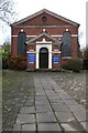
1
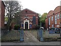
Stourbridge Unitarian Church
The building, in Lower High Street, was constructed in 1788 as a Presbyterian church, on a site that had already been used for worship for ninety years. https://www.worcesteranddudleyhistoricchurches.org.uk/index.php?page=stourbridge-unitarian-church
Image: © A J Paxton
Taken: 15 Jul 2017
0.06 miles
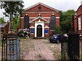
2
The Unitarian Chapel
This building dates from 1788 and is Grade II listed https://historicengland.org.uk/listing/the-list/list-entry/1343195?section=official-list-entry as a Presbyterian Chapel, as does Pevsner, but clearly from the signage it is an Unitarian Chapel today.
Image: © Philip Halling
Taken: 4 Mar 2022
0.06 miles
3
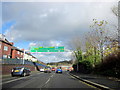
A451 Bath Road Stourbridge Showing Road Sign
Image: © Roy Hughes
Taken: 1 Nov 2014
0.06 miles
4
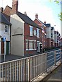
The former Cottage Inn (1), 49 Enville Street, Stourbridge
This pub closed some time ago, and has now been converted into apartments. The former signs above the ground floor windows, and to the left of the left-most window, have been removed, but a plaque remains between the first floor windows. It looks as if there was also a sign on the left wall, which has also been removed. Beyond the pub, the previous buildings have been demolished, and on the site new retirement apartments have been built.
The plaque:- Image
In June 2011, the pub was photographed by Chris Whippet. It was possibly already closed, but the signage was still there. See:- Image
Image: © P L Chadwick
Taken: 16 Oct 2011
0.07 miles
5
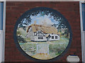
The former Cottage Inn (2) - plaque, 49 Enville Street, Stourbridge
Following the recent conversion of this former pub to apartments, this plaque between the first floor windows on the front wall remains. The colours have faded, but it is still possible to see that the idyllic picture of a thatched cottage bears absolutely no resemblance to the present building!
Image
Image: © P L Chadwick
Taken: 16 Oct 2011
0.07 miles
8
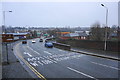
Stourbridge ring road in the rain
The weather conditions possibly add to preconceptions about the Black Country.
Image: © Bill Boaden
Taken: 2 Jan 2016
0.07 miles
9
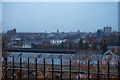
Stourbridge town centre on a wet winter afternoon
The view from Stourbridge FC's ground at Amblecote.
Image: © Bill Boaden
Taken: 2 Jan 2016
0.07 miles