IMAGES TAKEN NEAR TO
Union Street, STOURBRIDGE, DY8 1PR
Introduction
This page details the photographs taken nearby to Union Street, DY8 1PR by members of the Geograph project.
The Geograph project started in 2005 with the aim of publishing, organising and preserving representative images for every square kilometre of Great Britain, Ireland and the Isle of Man.

There are currently over 7.5m images from over14,400 individuals and you can help contribute to the project by visiting https://www.geograph.org.uk
Image Map
Images are licensed for reuse under creativecommons.org/licenses/by-sa/2.0
Notes
- Clicking on the map will re-center to the selected point.
- The higher the marker number, the further away the image location is from the centre of the postcode.
Image Listing (131 Images Found)
Images are licensed for reuse under creativecommons.org/licenses/by-sa/2.0
Image
Details
Distance
1
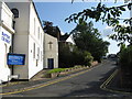
The former Stourbridge Labour Club, 31-33 Hagley Road
These large premises were the home of the Stourbridge Labour Club & Institute Limited, but are now up for sale.
Image: © P L Chadwick
Taken: 28 Jun 2009
0.06 miles
2
The Hagley Road
The Hagley Road passing the KIA dealership in Stourport.
Image: © Philip Halling
Taken: 4 Mar 2022
0.06 miles
3
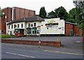
Old Swinford Hospital
This was the site of Stourbridge College which underwent a merger with Birmingham Metropolitan College in 2013, two years later this campus underwent a £5m makeover. In 2019, this campus closed and students moved to other campuses such as Dudley. The buildings were then sold off to the adjoining boarding school, Old Swinford Hospital which dates back to 1667.
Image: © Philip Halling
Taken: 4 Mar 2022
0.07 miles
4
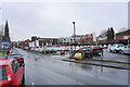
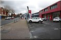
Union Street and Kia car dealership
Just outside the ring road. Viewed on a wet day.
Image: © Bill Boaden
Taken: 2 Jan 2016
0.09 miles
5
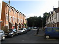
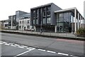
Stourbridge - Park Street's modern terraced housing
Estate agents would prefer you to call them Townhouses. Several on sale and probably some bargains to be had in September 2008's market, provided you don't need to park a car.
Image: © Peter Whatley
Taken: 13 Sep 2008
0.11 miles
6
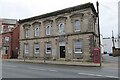
Former County Court
Stourbridge's former County Court on Hagley Road. The building dates from the mid-19th century and is Grade II listed, see: https://historicengland.org.uk/listing/the-list/list-entry/1076050?section=official-list-entry
Image: © Philip Halling
Taken: 4 Mar 2022
0.12 miles
7
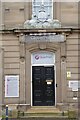
Entrance to the former County Court
Now a solicitors the building still retains the Royal Coat of Arms above the door.
Image: © Philip Halling
Taken: 4 Mar 2022
0.12 miles
8
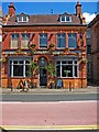
The Swan, 5 Hagley Road
Not far from Stourbridge's terrifying ring road is this popular pub with restaurant. It is on Hagley Road, which is also part of the A491.
Image
Image: © P L Chadwick
Taken: 25 Jun 2010
0.12 miles
9
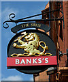
The Swan (pub sign), 5 Hagley Road
The Swan has a typical Banks's Brewery sign, with the brewery lion and the pub name above. Some of Banks's pubs are being rebranded as Marstons. If this happens to The Swan, then it may get an individual sign.
Image
Image: © P L Chadwick
Taken: 25 Jun 2010
0.12 miles