IMAGES TAKEN NEAR TO
The Heathlands, STOURBRIDGE, DY8 1NR
Introduction
This page details the photographs taken nearby to The Heathlands, DY8 1NR by members of the Geograph project.
The Geograph project started in 2005 with the aim of publishing, organising and preserving representative images for every square kilometre of Great Britain, Ireland and the Isle of Man.

There are currently over 7.5m images from over14,400 individuals and you can help contribute to the project by visiting https://www.geograph.org.uk
Image Map
Images are licensed for reuse under creativecommons.org/licenses/by-sa/2.0
Notes
- Clicking on the map will re-center to the selected point.
- The higher the marker number, the further away the image location is from the centre of the postcode.
Image Listing (67 Images Found)
Images are licensed for reuse under creativecommons.org/licenses/by-sa/2.0
Image
Details
Distance
1
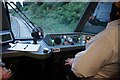
Stourbridge Shuttle towards Stourbridge Junction
Image: © Ian S
Taken: 3 Sep 2021
0.03 miles
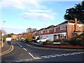
7
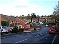
Houses on Cranbourne Road
Houses on Cranbourne Road, off Hagley Road.
Image: © Philip Halling
Taken: 4 Mar 2022
0.12 miles
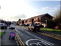
8
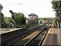
Stourbridge Junction station northern approaches
On the extreme left, the line to Stourbridge Town curves away and begins its steep descent to the town. Beyond the signalbox, a spare diesel set awaits its next duty and in the distance a train is curving off toward Birmingham via Cradley Heath.
Image: © Peter Whatley
Taken: 13 Sep 2008
0.15 miles
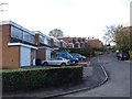
9
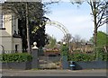
The Labour in Vain, entrance to garden in Brook Road, Oldswinford
The attractive entrance, with its arch, to the garden of this popular pub.
Image
Image: © P L Chadwick
Taken: 24 Apr 2010
0.15 miles
10
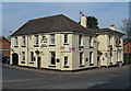
The Labour in Vain, 59 Red Hill, Oldswinford
A large and very long established pub on the corner of Red Hill and Brook Road. In 1822 it was known as The Malt Shovel. Outside it has a standard type Banks's Brewery sign. Originally it had its own sign with an illustration of the presumed origin of its name. This would today be judged offensive by most people and has understandably been removed. However some of the pub's windows, which are regarded as of historic interest, illustrate the same theme.
The large banner displayed on the corner of the pub is nothing to do with the 2010 General Election, but celebrates the pub being the winner in the Stourbridge News Support your Local competition in 2009.
Image
Image: © P L Chadwick
Taken: 24 Apr 2010
0.15 miles