IMAGES TAKEN NEAR TO
Junction Road, STOURBRIDGE, DY8 1JX
Introduction
This page details the photographs taken nearby to Junction Road, DY8 1JX by members of the Geograph project.
The Geograph project started in 2005 with the aim of publishing, organising and preserving representative images for every square kilometre of Great Britain, Ireland and the Isle of Man.

There are currently over 7.5m images from over14,400 individuals and you can help contribute to the project by visiting https://www.geograph.org.uk
Image Map (Loading...)


Getting Data...Please wait
Leaflet Map data © OpenStreetMap
Images are licensed for reuse under creativecommons.org/licenses/by-sa/2.0
Notes
- Clicking on the map will re-center to the selected point.
- The higher the marker number, the further away the image location is from the centre of the postcode.
Image Listing (134 Images Found)
Images are licensed for reuse under creativecommons.org/licenses/by-sa/2.0
Image
Details
Distance
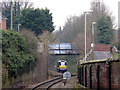
2
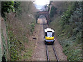
People Mover descending the branch line
The single-car shuttle unit that now operates the Stourbridge Junction to Stourbridge Town branch (less than a mile long) is the experimental Parry People Mover. So far, this is the only National Rail line on which they are used. Here it is seen descending the steeply graded branch towards the Town station. See from Parkfield Road bridge.
Image: © Stephen Craven
Taken: 7 Feb 2015
0.05 miles
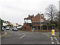
4
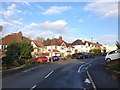
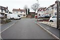
Parkfield Road
The road straight ahead is Parkfield Road. As it turns to the viewer's left it becomes Vauxhall Road.
Image: © P L Chadwick
Taken: 13 Mar 2009
0.06 miles
5
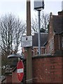
Sign of the times
One of the many measures undertaken in recent years to try and combat the problem of excessive drinking is the declaration of alcohol free zones. This sign warns that in this area the drinking of alcohol is prohibited by law.
Image: © P L Chadwick
Taken: 13 Mar 2009
0.07 miles
7
People Mover heading back uphill
The single-car shuttle unit that now operates the Stourbridge Junction to Stourbridge Town branch (less than a mile long) is the experimental Parry People Mover. So far, this is the only National Rail line on which they are used. Here it is seen ascending the steeply graded branch back to the main line.
Image: © Stephen Craven
Taken: 7 Feb 2015
0.08 miles
8
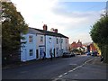
Parkfield Road, Stourbridge
Looking up the road from the railway bridge.
Image: © Stephen Craven
Taken: 7 Feb 2015
0.08 miles