IMAGES TAKEN NEAR TO
Dene Avenue, KINGSWINFORD, DY6 9TJ
Introduction
This page details the photographs taken nearby to Dene Avenue, DY6 9TJ by members of the Geograph project.
The Geograph project started in 2005 with the aim of publishing, organising and preserving representative images for every square kilometre of Great Britain, Ireland and the Isle of Man.

There are currently over 7.5m images from over14,400 individuals and you can help contribute to the project by visiting https://www.geograph.org.uk
Image Map
Images are licensed for reuse under creativecommons.org/licenses/by-sa/2.0
Notes
- Clicking on the map will re-center to the selected point.
- The higher the marker number, the further away the image location is from the centre of the postcode.
Image Listing (9 Images Found)
Images are licensed for reuse under creativecommons.org/licenses/by-sa/2.0
Image
Details
Distance
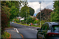
1
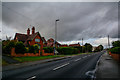
Kingswinford : Cot Lane
Looking along Cot Lane.
Image: © Lewis Clarke
Taken: 28 Sep 2019
0.10 miles
2
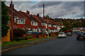
Kingswinford : Graham Road
Looking along Graham Road off Cot Lane.
Image: © Lewis Clarke
Taken: 28 Sep 2019
0.12 miles
3
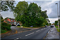
Kingswinford : Cot Lane
Looking along Cot Lane.
Image: © Lewis Clarke
Taken: 28 Sep 2019
0.14 miles
4
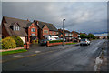
Kingswinford : Barnett Lane
Looking along Barnett Lane.
Image: © Lewis Clarke
Taken: 28 Sep 2019
0.21 miles
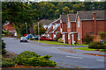
5

Kingswinford : Barnett Lane
Looking along Barnett Lane.
Image: © Lewis Clarke
Taken: 28 Sep 2019
0.21 miles
6
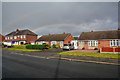
Kingswinford : Barnett Lane
Looking towards a rainbow above the houses on Barnett Lane.
Image: © Lewis Clarke
Taken: 28 Sep 2019
0.22 miles
7
Kingswinford : Middleway Avenue
Looking along Middleway Avenue off Cot Lane.
Image: © Lewis Clarke
Taken: 28 Sep 2019
0.23 miles
8
Kingswinford : Cot Lane
Looking along Cot Lane.
Image: © Lewis Clarke
Taken: 28 Sep 2019
0.24 miles
9
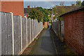
Kingswinford : Footpath
A footpath between Barnett Lane and Arlington Close.
Image: © Lewis Clarke
Taken: 28 Sep 2019
0.24 miles