IMAGES TAKEN NEAR TO
Sandmeadow Place, KINGSWINFORD, DY6 9RF
Introduction
This page details the photographs taken nearby to Sandmeadow Place, DY6 9RF by members of the Geograph project.
The Geograph project started in 2005 with the aim of publishing, organising and preserving representative images for every square kilometre of Great Britain, Ireland and the Isle of Man.

There are currently over 7.5m images from over14,400 individuals and you can help contribute to the project by visiting https://www.geograph.org.uk
Image Map
Images are licensed for reuse under creativecommons.org/licenses/by-sa/2.0
Notes
- Clicking on the map will re-center to the selected point.
- The higher the marker number, the further away the image location is from the centre of the postcode.
Image Listing (7 Images Found)
Images are licensed for reuse under creativecommons.org/licenses/by-sa/2.0
Image
Details
Distance
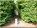
1
Ridge Road looking toward Dudley and the Black Country
Image: © charlie
Taken: 21 Apr 2011
0.17 miles
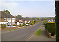
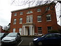
3
Broadfield House Glass Museum
A specialist museum run by Dudley Metropolitan Borough Council. It has since closed (2015).
Image: © Richard Sutcliffe
Taken: 21 Jun 1981
0.22 miles
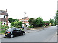
4
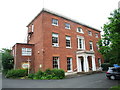
Broadfield House Glass Museum, Kingswinford
Image: © Chris Whippet
Taken: 18 Jun 2010
0.22 miles
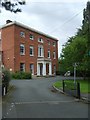
5
Broadfield House Glass Museum, Kingswinford
Image: © Ruth Sharville
Taken: 5 Feb 2011
0.23 miles
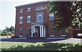
6
Broadfield House
The Glass Museum stands on Compton Drive.
Image: © Gordon Griffiths
Taken: 20 Aug 2008
0.24 miles